Specifications |
Scanner general specifications
| Specification | UR3 | XR3-C, XR3-CT |
XR3-D, XR3-CD |
SR3 | |
|---|---|---|---|---|---|
| Type | Terrestrial laser scanner | ||||
| Dimensions | Height | 390 mm | 390 mm | 390 mm | 390 mm |
| Depth | 192 mm | 192 mm | 192 mm | 192 mm | |
| Width | 342 mm | 318 mm | 318 mm | 318 mm | |
| Height to UNC thread | Scanner1 | 375.5 mm | 375.5 mm | 375.5 mm |
378.5 mm |
| Off-centre mount2 | - | 405.5 mm | |||
| Weight3 | 12.1 kg | 10.1 kg | 10.3 kg | 10.1 kg | |
| Battery | Type | Li-ion | |||
| Run time | 2.0 hours | ||||
| Levelling | Fine | 20″ | |||
| Coarse | 1° over any tilt | ||||
| Normal temperature range | Regular | 0° to +50°C | |||
| M20 | -20° to +50°C | ||||
| Limited exposure temperature range | -40° to +50°C (according to limited exposure time below) |
||||
| Limited exposure time | Regular | 20 minutes
(starting from +20°C) |
|||
| M20 | 8 hours (starting from +20°C with neoprene jacket and external power) |
||||
| Storage temperature | -40° to +70°C | ||||
| Magnetic compass | ±1° (assumes no metallic objects or magnetic field interference) |
||||
| Internal GNSS receiver | L1 GPS + QZSS | ||||
| Protection class | IP-65 (IEC 60529) | ||||
| Data recorder | Wireless ruggedised tablet controller plus onboard USB | ||||
| Mounting | Internal 5⁄8″ UNC thread and T-bolt slots | ||||
| GPS mount | External 5⁄8″ UNC thread | ||||
Laser rangefinder
| Specification | UR3 | XR3-C, XR3-CT |
XR3-D, XR3-CD |
SR3 | |
|---|---|---|---|---|---|
| Type | Time of flight pulsed rangefinder | ||||
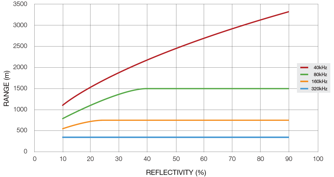
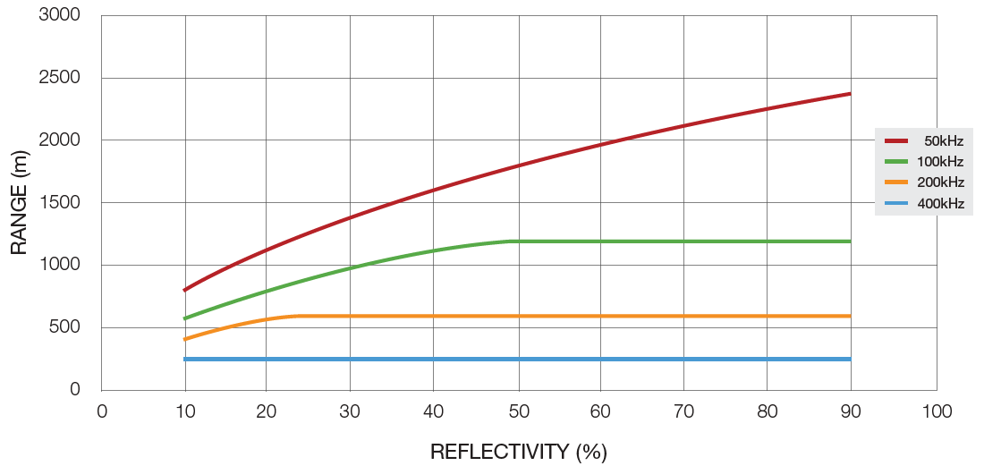
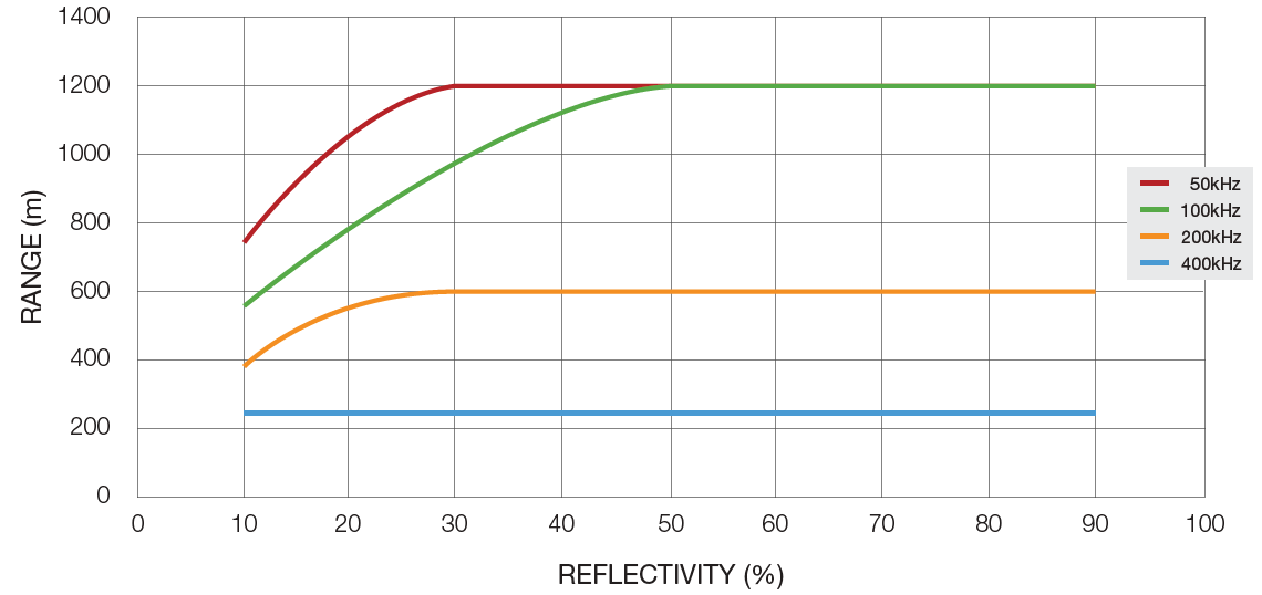
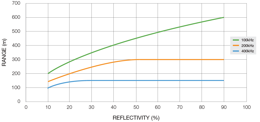
| Range4 | Maximum | 3500 m | 2800 m | 1200 m / 600 m (dual) |
600 m off reflector |
| Minimum | 5 m | 2.5 m | 2.5 m | 1 m | |
| Performance5 | Accuracy | 5 mm | 5 mm | 5 mm | 4 mm |
| Repeatability | ±4 mm | ||||
| Exit aperture | < 10 mm | < 8 mm | < 8 mm | < 8 mm | |
| Beam divergence (1/e2 radius) | 0.4 mrad | 0.25 mrad | |||
| Acquisition rates | Normal | 40 kHz | 50 kHz | 50 kHz | - |
| Fast | 80 kHz | 100 kHz | 100 kHz | 100 kHz | |
| Rapid | 160 kHz | 200 kHz | 200 kHz | 200 kHz | |
| Ultra | 320 kHz | 400 kHz | 400 kHz | 400 kHz | |
| Laser class | Class 1 (IEC 60825-1:2014) | ||||
| Wavelength | Near infrared | ||||
| Intensity measurement | Yes | ||||
| Angular step selectable | 0.2° to 0.0125° | 0.2° to 0.0125° | 0.2° to 0.0125° | 0.2° to 0.025° | |
| Vertical scanning range | Lower elevation | -40° | -40° | -40° | -40° |
| Upper elevation | +40° | +50° | +60° (D) +50° (CD) +40° (D dual) +30° (CD dual) |
+90° (zenith) | |
| Total extent | 80° | 90° | 100° (D) 90° (CD) 80° (D dual) 70° (CD dual) |
130° | |
| Horizontal scanning range | 360° | ||||
Range versus reflectivity
Scan point density
| Point density setting | Azimuth resolution (° per step) |
Elevation resolution (° per step) |
Theoretical maximum point count (millions of points)6 |
|||
|---|---|---|---|---|---|---|
| UR3 | XR3-C, XR3-CT, XR3-CD |
XR3-D | SR3 | |||
| 1 | 0.2° | 0.2° | 0.72 M | 0.81 M | 0.9 M | 1.17 M |
| 27 | 0.1° | 0.1° | 2.88 M | 3.24 M | 3.6 M | 4.68 M |
| 4 | 0.05° | 0.05° | 11.52 M | 12.96 M | 14.4 M | 18.72 M |
| 8 | 0.025° | 0.025° | 46.08 M | 51.84 M | 57.6 M | 74.88 M |
| 168 | 0.0125° | 0.0125° | 184.32 M | 207.36 M | 230.4 M | - |
Digital camera
| Specification | UR3, XR3-C, XR3-CT, XR3-CD | SR3 |
|---|---|---|
| Type | 20 MP CMOS HDR digital panoramic camera | |
| Angular range | 60° vertical, 360° horizontal | 80° vertical, 360° horizontal |
| Lens | Zeiss 28 mm, with filter | Voigtländer 21 mm, with filter |
| Pixel resolution | 147 MP | |
| Acquisition method | During laser scan | |
| Exposure control | User definable | |
| Depth of field | 5 m to infinity | |
| Image render method | Corrected image automatically rendered to scan in PointStudio | |
Laser aimer (SR3 only)
| Specification | Value |
|---|---|
| Type | 635 nm red laser |
| Product laser class | Class 1 |
Telescope (XR3-CT only)
| Specification | Value |
|---|---|
| Angular range | 80° vertical, 360° horizontal |
| Focal range | 5 m to infinity |
| Focus control | Electronic motorised focus |
| Objective aperture | 28 mm |
| Magnification | 14x |
| Reticule | Crosshair |
| Field of view | 3° in field |
| Resolving power | ±5″ |
| Minimum azimuth step | 3.6″ |
FieldHHC tablet
| Specification | Value | |
|---|---|---|
| Type | Panasonic Toughbook FZ-G2 ruggedised tablet PC | |
| Durability | IP65 water and dust resistant, drop resistant | |
| Operating temperature range | -29°C to +63°C | |
| Dimensions (W x H x D) | 279 mm x 188 mm x 23.5 mm | |
| Weight | Approximately 1.19 kg | |
| RAM | 16 GB | |
| Storage | 512 GB | |
| Display | 10.1″ LCD 1920 x 1200 sunlight-viewable capacitive touchscreen | |
| Camera | 8 MP with autofocus and LED flash | |
| Battery run time | Approximately 7.5 hours | |
| AC adapter | Input | 100 V – 240 V AC, 50 Hz / 60 Hz |
| Output | 15.6 V DC, 7.05 A | |
Note: Maptek acknowledges the use of various Third Party software and associated licences as part of the system components of the FieldHHC software. A full list of Third Party Software can be found at www.maptek.com/legal/.
Network settings
| Setting | Value |
|---|---|
| Ethernet IP address (tablet controller) | 10.105.8.50 |
| Ethernet IP address (scanner) | 10.105.129.5 |
| Wi-Fi IP address (tablet controller) | 192.168.1.50 |
| Wi-Fi IP address (scanner) | 192.168.1.5 |
| Subnet mask | 255.255.0.0 |
Was this page helpful?
