Query Scanlines
Report on discontinuity with a scanline.
The aim of the scanline is to map the discontinuities that cross a line on a rock exposure. A line is drawn/painted across the face which usually can be: horizontal, vertical or at an angle. The required parameters are then detailed for each discontinuity crossing the line. This line is imagined as a straight line for input to PointStudio, much like a borehole, despite the fact that an underground rock face is not planar and the painted line follows these irregularities in the face, hence it is not millimetre perfect in practice.
-
On the Geotechnical ribbon tab navigate to the Scanline group and select
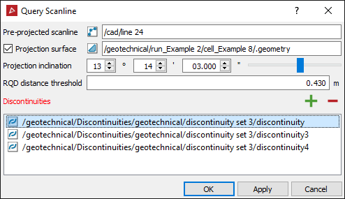
 Query Scanline.
 -
Select all the discontinuities from the project explorer and with the middle mouse button click and drag them into the panel.
-
Select the projected scanline into the panel.
-
Select the projection surface into the panel (if any).
-
Set the projection inclination.
-
Click OK or Apply.