Glossary
Source file: glossary.htm
| Term | Definition | ||||
|---|---|---|---|---|---|
| Batter | Refers to the slope of a wall. For example, an excavator digs to a 'batter angle' to achieve a dig wall to the design batter angle. | ||||
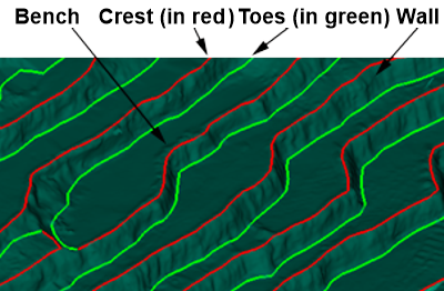
| Bench |
When a high wall becomes too high for safety, a bench is used to act as a buffer for falling rocks. This is where a digging machine, such as an excavator or dragline, sits while digging material below this level.
|
||||
| Breakline | A line with a series of vertices that defines points of inflection in the topographic surface of the earth. That is, places where there are sharp changes in the direction of slope on the earth's surface. | ||||
| Chainage | Chainage, or running distance is the distance along a curved or straight survey line from a fixed commencement point. Similar to mileage. Alternatively, a length as measured by a surveyor's chain or tape. | ||||
| Crest | The line along the top of a wall. | ||||
| Database | Another name for the working file for data in Maptek software. All data are contained within the database file, but are not accessible from Windows. See Projects. | ||||
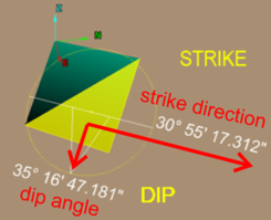
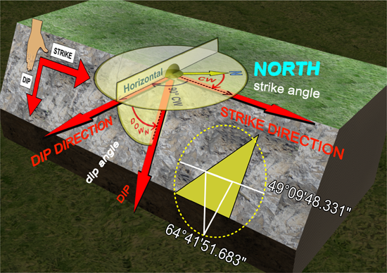
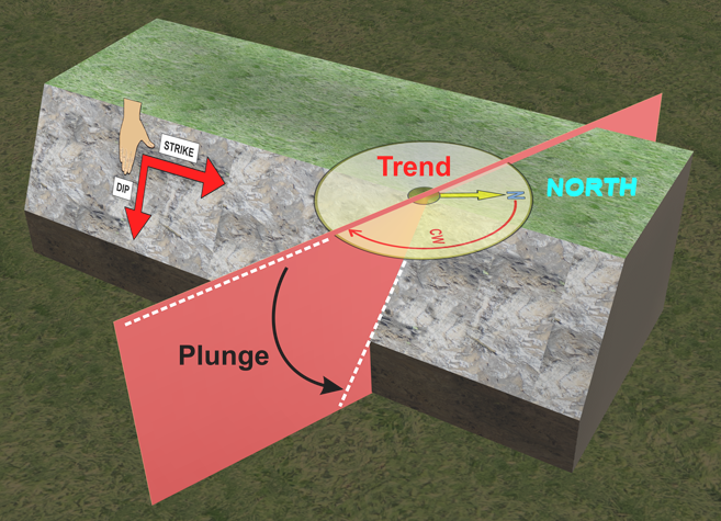
| Dip, Dip Angle, Dip Direction |
Dip angle (0° to 90°) is the steepest angle of descent of a tilted bed or feature, relative to a horizontal plane . Dip direction (0° to 360°) is the horizontal direction of the dip, measured clockwise from north. Strike direction, also measured clockwise from north, is dip direction minus 90°. The basis for this orientation system is the American Right Hand Rule, as follows:
|
||||
|
|
|
||||
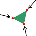
| Edges | Straight lines that join the vertices of a facet form its edges. |
|
|||
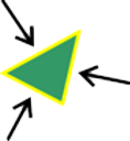
| Facet | A simple plane represented by a filled triangle with co-planar vertices. Facets are used as basic building blocks for 3D surfaces in software. A surface is made up of a collection of facets joined together to approximate the shape of a real object, or to create a custom or a virtual object. | ||||
|
|
|
||||
| Facet network | See Surface/Triangulation on this page. | ||||
| Frustum | The part of a solid, such as a cone or pyramid, between two parallel planes cutting the solid, especially the section between the base and a plane parallel to the base. | ||||
| Geodesy | The study of the shape of the Earth and the determination of the exact position of geographical points (latitude, longitude, and elevation). Geodetic describes an activity relating to geodesy. A Geodesist is a person undertaking geodetic work. | ||||
| Great circle | A great circle of a sphere is the intersection of the sphere surface and a plane that passes through the centre point of the sphere. | ||||
| Poisson technique | A statistical method for predicting the distribution of data points. | ||||
| Project | A project file stores data and results of analyses which can be opened in a project session. The project file (also termed a database file) uses the extension .maptekdb and can't be accessed by other programs. | ||||
| Rill | See Windrow on this page. | ||||
| Rose diagram | A circular histogram plot that displays directional data and the frequency of each class. | ||||
| Stereonet | A stereonet (or stereogram or hemispherical projection) is a way of representing 3-dimensional directions on a 2-dimensional surface. The net is a projection from the point onto the equator. | ||||
| Strike | The strike line of a bed, fault, or other planar feature is a line representing the intersection of that feature with a horizontal plane. On a geologic map, this is represented with a short straight line segment oriented parallel to the strike line. See Dip, Dip Angle, Dip Direction on this page. | ||||
| Surface/Triangulation | A collection of joined facets used to represent a 3D object. Properly formed surfaces consist of non-overlapping triangles only. That is, no other shapes, and each point only connects to two or three others. |

|
|||
| Toe | The line along the base of a wall. | ||||
| Trend and Plunge |
Trend and plunge refer to the characteristics of a linear geological feature and are related to the dip and strike of a slope. Trend is the angle to the line of the feature, measured clockwise from north. Plunge is the vertical angle dropping from a horizontal line to the feature line where it sits along the slope. Note that the plunge is generally less than the dip of the slope. When the feature runs perpendicular to the strike of the slope, the plunge will be equal to the dip of the slope.
|
||||
| Vertices (pl) Vertex (sing) |
Points that define the corners of facets. |
|
|||
| Wall | Steeply angled slope between a crest and a toe. | ||||
| Windrow | Loose material that has been pushed to an edge, generally used to prevent vehicles from driving off high walls or outside of designated roads, as well as for establishing boundaries. | ||||