Long Section
Use the Long Section option to view the natural surface along the alignment, i.e. a long section view of the terrain. This is used for looking at the terrain under a horizontal alignment and for designing vertical intersection points (IPs) and alignments.Instructions
On the Iroad menu, point to Edit, and then click Long Section.
Select the alignment. You will need to confirm that the correct alignment has been selected. If a default topography has not been set, then you will be prompted to select a topography triangulation first. Refer to the Topography option for more information.
The following panel is then displayed.

Vertical scale
Enter a scale for the long section. The vertical scale is important for maintaining a fixed ratio between chainage and elevation when producing plots. The default scale is '1.00'.
Click OK.
The long section is generated and you are placed in long section view with an option to return to plan view.
The long section window displays the data with increasing chainage in the X direction and elevation in the Y direction. The alignment string is the same object as in the plan window, but seen in a different view. Associated with the alignment is what is known as an Inverse Radius Diagram. This is a means of correlating the curves on the horizontal alignment with the vertical grades.
The long section data is stored in a layer named <design_name>.L. The objects in this layer consist of the natural surface (named NSXSECT) and, if any, subsurfaces (named SBXSECT).
1 shows an inverse radius diagram with deviations from a zero level, in inverse proportion to the radius of curvature of horizontal alignment.
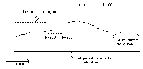
1- Inverse Radius Diagram

