Vulcan Grid Model
Use Vulcan Grid Model to create a Vulcan grid model. The difference between this option and the Create Simple option is that this option incorporates interpolation and smoothing algorithms.
The parameters of the grid, size, modelling method etc., are stored in a specification file <proj><gfi>.<mv>n. The grids created from this specification have the file name format <proj><gfi>.<mv>g.
This option uses a mapfile (either already existing or created from a design or geological database) to create the grid.
Instructions
On the Model menu, point to Grid Mesh Surfaces, and then click Vulcan Grid Model to display the Structure Specifications panel.
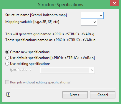
Structure name
Enter the grid file identifier, which is also referred to as the structure name or the mapfile identifier (<mfi>). The maximum size of the structure name is five (5) alphanumeric characters. Spaces are not allowed. If a horizon file exists (<proj>strata.hzl), then structures can be selected from a drop-down list.
Mapping variable
Enter the mapping variable that represents the Fortran format statement that describes the format of the data in the mapfile. Mapping variables may be user defined (in the .scd file) or standard (delivered with the system). The standard variables are shown below. Appendix D of the Vulcan Core documentation lists the fields that are supported in a Fortran format statement.
The mapping variable becomes the model variable (<mv>) part of the resultant Vulcan grid model name.
| Mapping Variable | Fortran Format Statement |
|---|---|
| LC (location) | (A8,T35,A5,T9,2F12.3,T41,F8.3) |
| DR (depth to roof) | (A8,T35,A5,T9,2F12.3,T49,F8.3) |
| DF (depth to floor) | (A8,T35,A5,T9,2F12.3,T57,F8.3) |
| SR (structure roof) | (A8,T35,A5,T9,2F12.3,T65,F8.2) |
| SF (structure floor) | (A8,T35,A5,T9,2F12.3,T73,F8.2) |
| TK (thickness) | (A8,T35,A5,T9,2F12.3,T81,F8.3) |
| MD (mid burden) | (A8,T35,A5,T9,2F12.3,T89,F8.3) |
| PT (parting) | (A8,T35,A5,T9,2F12.3,T97,F8.3) |
| OB (overburden) | (A8,T35,A5,T9,2F12.3,T105,F8.3) |
| ST (structural thickness) | (A8,T35,A5,T9,2F12.3,T113,F8.3) |
| TP (topography) | (A1,A3,3F16.3) |
When entering a mapping variable, the system first checks whether the variable exists in the scheme file. If not, it checks whether it is a variable delivered with the system. This means that if there is a LC variable in the scheme file it will take precedence over the one delivered with the system.
The variable codes delivered with the system are not necessarily the ones applicable to your mapfiles.
You can create new specifications, use existing specifications in which case you will need to supply the specifications file name or you can use the default specifications. The default specifications are the previously used specifications.
Run job without editing specifications
Select this check box to generate the model without having to go through all subsequent panels (which are used for editing the specifications). This option is only applicable when using existing or default specifications
Click Next.
The following panel is then displayed.
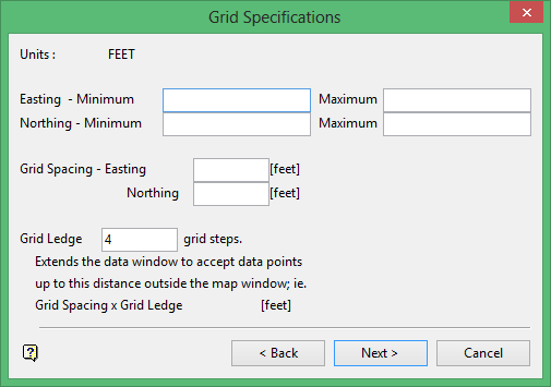
Easting/Northing
Enter the maximum and minimum co-ordinates to define the map or grid extents, i.e. the area over which the grid will be created.
Grid Spacing
Enter the grid spacing. The spacing must divide evenly (i.e. no remainder) into the grid extent dimensions.
Grid Ledge
Enter the number of steps of grid spacing to add to the grid extents to create the ledge. Data in the 'ledge' will be used to create the grid model. Thus you can use data not in the grid extents to generate the grid.
Click Next.
The following panel is then displayed.
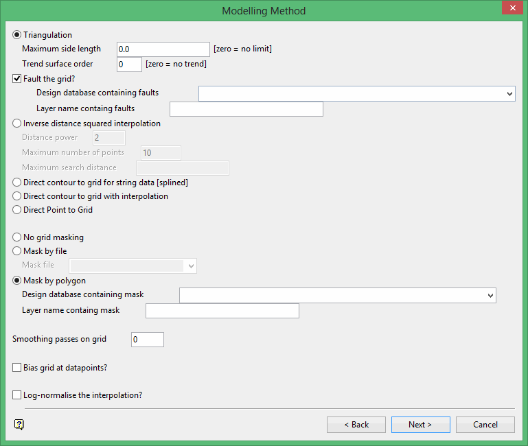
Only one of the five (5) modelling methods can be used at a time.
The methods are:
Triangulation
This method uses the Delauney triangulation algorithm. It is the most commonly used technique for modelling sedimentary structures and as such is the only technique to permit fault interpolation.
This method should not be used if the original data is in the form of contours or strings. Use the Direct contour to grid method instead.
Maximum side length
Specify the maximum length of a triangle side. This will control edge triangles and thereby stop triangles forming along concave edges of the data. These triangles may result in distortion along the edge of the map when interpolation takes place.
Trend surface order
Specify a trend surface order. Enter 0 if you don't want to use a trend surface.
For information on trend surfaces refer to Grid Calc > Data > Trend.
Fault the grid
Select this check box to fault the grid. You will need to specify the design database and layer containing the faults.
Inverse distance squared interpolation
This method is an averaging method of computing an interpolated value for each grid node. For each consecutive grid node across the map area, a local search is performed around each node in search of a minimum number of data points. When this number of points is "collected", an average of these points is computed. In calculating the average each point is allocated a particular weighting based on the inverse distance (to some specified power) of the point to the node (that is the further way the point the lower the weighting).
The grid modelling inverse distance method is not the same as the ellipsoidal search region of the block modelling inverse distance. The grid inverse distance code does not use a search radius in the same sense. The grid inverse distance searches for a number of points, not by radius. The search radius is merely used to determine the status of the mask value.
The grid inverse distance starts with a zero radius and increases that radius until the required number of points is found. If, however, the radius exceeds the specified maximum, the value is interpolated, but the mask value for that node is set to zero. If a radius is not specified, then a maximum radius is calculated based on your grid dimensions. However, since this only affects the mask, you should remask the grid or unmask it to see the effects.
Specify the distance power, maximum number of points and maximum search distance.
Direct contour to grid for string data (splined)
This method uses a one dimensional cubic spline that is fitted to each row and column of the grid to contour the model. From these splines two estimates are available for each grid node's Z value. The method chooses the value related to the steeper slope as being the most reliable.
Direct contour with interpolation
This method triangulates new values to form a large number of triangles from which the nodes are estimated.
Direct Point to Grid
This method applies to points that have been surveyed on a regular grid, for example surveys carried out on a 100m grid basis. The method reads the survey values directly onto the grid, i.e. no interpolation occurs.
The masking options allow you to modify the default visible area that is specified by the mapping window. You may need to change this area if not all data is visible.
No grid masking
Select this option to not mask the data (i.e. all of the data - if it fits in the current window extents - is visible.
Mask by file
Select this option to specify a mask file to mask the grid. The mask file, which must have the same header as the grid to be masked, i.e. the same mapping window and grid size, is generated using Vulcan or Vulcano menus. Vulcan makes a mask file from a specified design layer. This option is mainly used for sites that have predefined mask files.
Mask by polygon
Select this option to specify polygon(s) to be used to define the mask. Specify the design database and layer that contains the polygon(s).
A clockwise polygon delineates a visible (masked in) area, an anti-clockwise polygon delineates an invisible (masked out) area. Any number of polygons can be used to define the mask.
Each polygon must not be self-intersecting, but polygons may lie in one another if they are of the correct sense; i.e. you can have a clockwise polygon that completely encloses one or more anti-clockwise polygons. The clockwise polygon defining the visible area and the anti-clockwise polygons defining the invisible areas in it.
Smoothing passes on grid
Enter the number of smoothing passes on the grid. When the grid values have been entered, it is possible to refine the surface using a finite difference operator with predefined weights. This is analogous to a bi-cubic spine, like "stretching" the grid as though it were a rubber sheet. This produces a smoother surface that, in the case of a triangulation interpolation, will remove the sharp edges of the underlying triangulation.
The more passes, the smoother the grid will look. The full number of passes may, however, not be done if an earlier pass has not changed the variation significantly. Grid cells containing data points or faults are tied down and not moved by the smoothing process.
We recommend not to smooth an inverse distance interpolated grid.
Bias grid at data points
Select this check box to force the system to check whether each data point is at a local high, low or saddle point. If the point falls into one of these categories, then the immediately adjacent grid nodes will be slightly altered to ensure the local extreme is honoured and represented properly in the grid.
Log-normalise the interpolation
Select this check box to use the logarithm (base 10) when the data is being loaded. This option has the effect of de-amplifying the range of data. If the range of the data covers several log cycles (for example 10, 100, 1000), such as may occur with geochemical data, then the effect of applying logarithms to the data prior to interpolation is dramatic. The previously mentioned 10, 100 and 1000 respectively become 1, 2 and 3 as far as the system is concerned.
After the interpolation of the logged values, and prior to the creation of the grid, the logged data values are converted back to real numbers. The original data values are preserved, but interpolated values are considerably different to those produced when not using logs.
With data values of 10 and 1000 we expect the interpolated middle point to be about 500. However, with the logging option, the values become 1 and 3 and the middle point is 2, which when 'anti-logged' is 100.
This option is very useful for gold and uranium data, which is usually log-normally distributed. It heavily limits the influence of high and extreme values.
Click Next.
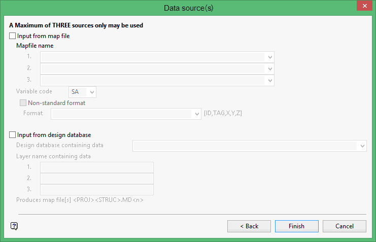
The Data source(s) panel is then displayed.
The options displayed through this panel are dependant upon the modelling method chosen through the Modelling Method panel.
Triangulation/Inverse distance squared interpolation
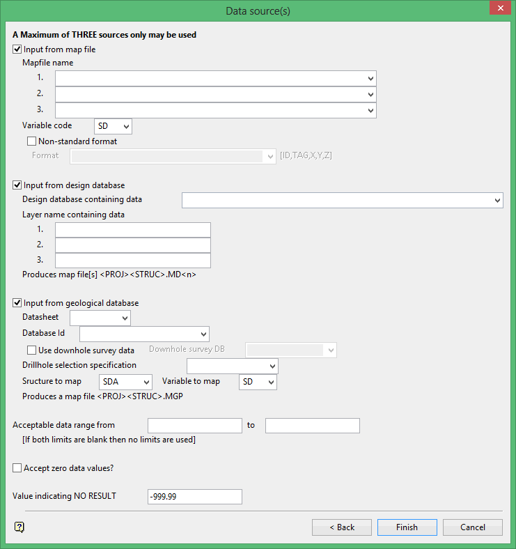
The data may come from up to three sources and may comprise mapfiles, design layers and a geological database. Each mapfile counts as one source, each design layer as one source and the geological database as one source.
Input from map file
Select this check box to use data from ASCII formatted map files. The variable code defaults to the mapping variable entered on the first panel. This can be overwritten.
If the variable is delivered with the system or setup in the scheme (.scd) file, then the Fortran format statement associated with that variable will be used to read the mapfile (the variable in the scheme file takes precedence).
If you have added new variables (with the Fortran format statement) to the scheme file, then these variables will appear (after the standard variables) in the drop-down list in the same order as they appear in the scheme file. These new variables will be considered to be standard variables and you will not need to check the Non-standard format check box. However, to aid you in defining non-standard formats, the Fortran format statements for these new variables will be added to the non-standard format drop-down list.
If you alter (in the scheme file) the Fortran format statement of a standard variable, then the new statement will replace the standard Fortran format for that variable. Thus you do not need to check the Non-standard format check box.
If no variable exists, then check the Non-standard format check box and manually enter the format. The fields supported in a Fortran format statement are listed in Appendix D of the Vulcan Core documentation.
Input from design database
Select this check box to use data from layers in a specified design database. Up to 3 layers can be selected. This option creates a mapfile as well as a grid.
The format of the mapfile name is <proj><mfi>.md<n> where <n> = the number of the selected layer (1, 2 or 3). The mapfile identifier is the same as the identifier (structure) specified on the Structure Specifications panel.
Generate mesh from
Specify whether you want to model the design object's Z-values or its W-tag values when attempting to create a Vulcan grid model.
Input from geological database
Select this check box to use data from a geological database, including a downhole survey database and, if a database query has been performed, data from a drill hole specification file. This option creates a mapfile as well as a grid.
The format of the mapfile name is <proj><mfi>MD<n> where <n> = the number of the selected layer (1, 2 or 3 ). The mapfile identifier is the same as the identifier (structure) specified on the Structure Specifications panel.
Acceptable data range [Optional]
Enter the maximum and minimum data values to limit the data being modelled.
If you are modelling thickness, you know nothing is thinner than zero (0) and you may know that your seam is no thicker than 10m; your range would therefore be 0-10 and all other data values will be ignored.
Accept zero data values
Select this check box to include 0 (zero) data values. Zero data values are often used to indicate no data entry.
Value indicating NO RESULT
Enter the value to be used when there is no data at all, i.e. not even a 0 (zero) value. Data with the specified value, for example -999.990, will be ignored in the creation of the model.
Click Finish.
The Grid Specifications dialog box is then displayed.
Save specifications and model
Saves the specifications and generates the model.
Save specifications and exit
Saves the specifications, but no model is generated.
Return to specification edit
Returns to the Data Source panel.
Discard specifications and CANCEL
Does not save the specifications.
Direct contour to grid for string data (splined)/Direct contour with interpolation/Direct Point to Grid
The data may come from up to three sources and may comprise mapfiles, design layers and a geological database. Each mapfile counts as one source, each design layer as one source and the geological database as one source.
Input from digi file
Select this check box to use data from DIGI formatted mapfiles. The variable code defaults to the mapping variable entered on the first panel. This can be overwritten.
Input from design database
Select this check box to use data from layers in a specified design database. Up to 3 layers can be selected. This option creates a mapfile as well as a grid. The format of the mapfile name is <proj><mfi>.md<n> where <n> = the number of the selected layer (1, 2 or 3). The mapfile identifier is the same as the identifier (structure) specified on the first panel.
Generate mesh from
Specify whether you want to model the design object's Z-values or its W-tag values when attempting to create a Vulcan grid model.
Click Finish.
The Grid Specifications dialog box is then displayed.
Save specifications and model
Saves the specifications and generates the model.
Save specifications and exit
Saves the specifications, but no model is generated.
Return to specification edit
Returns to the Data Source panel.
Discard specifications and CANCEL
Does not save the specifications.

