Open Database Multi Label Properties
Open a Drillhole Database
The option is identical to the Open Drillhole DB option under Washability Data.
Use the Open Database option to open a drillhole database, so that drillhole data can be graphically displayed.
There are two methods for displaying the traces. The first, the default, joins the survey points with line segments. The second, places a user specified number of interpolated points between the survey points. The trace is the curve that passes through all of the points.
Note: An option is available in Batch Plotting (Database Elements : Database Fields : Trace : Attributes) that allows you to plot the smoothed drill holes.
Instructions
On the Geology menu, point to Drilling, and then click Open Database.
Follow these steps:
-
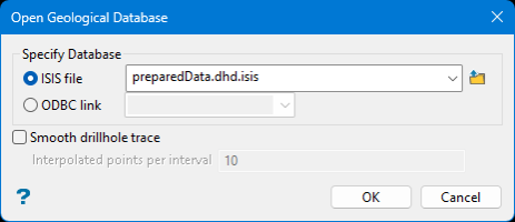
Specify Database
Isis File - Select this option to nominate an Isis database. The drop-down list displays all Isis database files found within your current working directory. Click Browse to select a file from another location.
ODBC Link - Select this option to nominate an ODBC link database. Select the design name from the drop-down list.
-
Select Smooth drill hole trace if you want the drill hole to be a curve passing through the survey points and a specified number of interpolated points. The alternative is to join the survey points with straight line segments, which can be unrealistic if there are few survey points and they differ significantly.
Note: The smoothing is for display purposed only.
Enter the number of points that you want placed between survey points in Interpolated points per interval.
Note: To remove the smoothing, you will need to reload the database.
-
Click OK.

