Define Variables 
Use the Define Variables option to define the type and source of the data to be modelled. The definitions are stored in the <proj><area>.gdc_spec file. All non-standard variables must be defined. Non-standard variables include all qualities, assays, densities, ratios, run of mine thickness, etc.
Instructions
On the Grid Calc menu, point to Edit Modelling Defaults, and then click Define Variables to display the Define Variable panel.
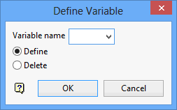
Variable name
Enter the variable name. A quality variable is made up of two characters, which are used in the grid naming convention, <proj><gfi>.<mv>g, where <gfi> is the grid file identifier (seam horizon) and <mv> is the model variable, for example, abcblue.asg where abc = project, blue = grid file identifier (seam), as = model variable (ash).
Define
Select this option to create or modify the above entered variable.
Delete
Select this option to delete the above specified variable.
Click OK to display the Variable Definition panel.
If the variable specified through the Define Variable panel is new, then you will be asked whether or not you want to create the variable before the Variable Definition panel displays. Select Create to proceed to the Variable Definition panel, or Cancel to exit the option.
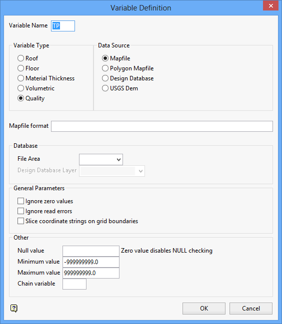
Variable Type
Select the required variable type (Roof, Floor, Material Thickness, Volumetric, Quality). Material thickness variables only include the material being mined for profit such as TK, ST and RM.
Data Source
Select the source of your data (Mapfile, Polygon (DIGI) Mapfile, Design Database, USGS DEM).
Mapfile Format
Enter the Fortran format statement for the mapfile. If a standard Vulcan mapfile is used, then this need only refer to the column number, for example, C3 or C7. These column numbers reflect the columns assigned to a mapfile in Borehole Graphics during structural or analytical mapfile generation. This option is only applicable to Mapfiles and Polygon Mapfiles.
Database
File Area
Enter, or select from the drop-down list, the name of the design database in which the layers reside. These data points or strings are then used in the modelling.
Design Database Layer
Enter, or select from the drop-down list, the name of the layers containing the data.
General Parameters
Ignore zero values
Select this check box to ignore zero data values. This option may be used when creating a model (for example, a quality model) where the database contains zero values that do not reflect real measured data.
Ignore read errors
Select this check box to ignore file read errors. These errors occur when incorrect data types are found in fields, for example, a character is found in an integer field.
Slice coordinate strings on grid boundaries
Select this check box to slice coordinate strings on grid boundaries. This is required for Spline modelling. This ensures a series of data points are created whenever data strings intersect grid cell boundaries.
Other
Null Value
Enter a value to be used as the null value. Values matching this in the data source will be ignored. Leaving this field blank, or entering a value of '0.0', will disable null checking.
Minimum Value
Enter a minimum allowable value for the modelling data.
Maximum Value
Enter a maximum allowable data for the modelling data.
Chain Variable
Enter the variable with which to associate this variable.
Click OK.
The specifications are written to a temporary file.
Use the Save Grid Specifications option to save the specifications.

