Lat/Long To XYZ
Convert Lat/Long Coordinates to XYZ Coordinates
The Lat/Long To XYZ option to convert geographic coordinates (latitude and longitude) based on the local spheroid to the Cartesian (XYZ) reference frame coordinates so that they can be used in manual GPS calculations. The converted coordinates displays in the Report Window.
Instructions
- Select Survey menu
- Select Transformations submenu
- Select Lat/Long To XYZ option
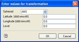
The following panel displays.

Enter values for transformation panel
Spheroid
Select the reference spheroid (also referred to as an ellipsoid) that will be used for the conversion. Currently this is set up for ANS (Australian National Spheroid), GRS80 and WGS (World Geodetic System). Contact your local Maptek office if you require another reference spheroid.
Latitude/Longitude
Enter the geographic coordinates. These should be entered in the format ddd.mmssttt where ddd = degrees, mm = minutes, ss = seconds, ttt = thousands of seconds.
Level
Enter the elevation of the point above sea level. This should be entered in local grid units as determined in the .dg1 file, For example, metres.
Select OK.
The converted coordinates are then displayed in the Report Window.
Note: If a UTM to Lat/Long function has just been performed, then the results of that function will be automatically loaded in the fields of the above panel.

