Load Mapfile Data
Use the Load Mapfile option to load mapfile data into memory. You then have the ability to triangulate or grid the data or perform various other manipulations.
This option can also be accessed by selecting the Load Mapfile button (  ) from the Grid Calc toolbar.
When loading a map file using Load Mapfile, it is important to specify the grid size on the Limits tab which will be used for modelling. Failure to do so may result in systematic errors in the modelling results due to a coordinate transformation that is applied to the data at the time of loading.
If you want to perform modelling with a different grid size than was specified during the loading of the data, it is best to first clear the data and reload in the desired grid size.
Instructions
On the Grid Calc menu, point to Data, and then click Load Mapfile to display the Load Mapfile panel.
Mapfile records with blanks in one or more of the field values (X, Y, and a user nominated Z) will be skipped.
Definition tab
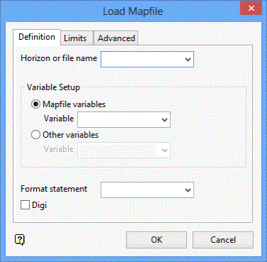
Horizon or file name
Enter, or select from the drop-down list, the name of the file containing the data. In the case of a mapfile, this option may be omitted if the data is to come from the mapfile for the current default structure. In the case of a design database, this qualifier may be omitted if the data is to come from the open design database. In either case, if a file is specified, then it is only necessary to supply the mapfile identifier or the spatial database identifier. For all other data sources, the file name must be specified in full.
Variable Setup
Choose one of the following options.
Mapfile variables
Select this option to select a modelling variable that is contained in the mapfile.
Other variables
Select this option to select variables that are not contained in the mapfile.
Format statement
Enter the format statement. If is either a Fortran format statement, indicating the column of data that should be extracted from the file, or a standard variable (for example, C1,..,C10, P1,..,P6, LC, DR, DF, SR, SF, TK, ST, PT, MD, OB). These variables define the column to be extracted if the mapfile is in the standard Vulcan format. A Fortran format statement should be of the usual form Aw,Aw,Fw.p,Fw.p,Fw.p.
Digi
Select this check box to load a DIGI mapfile. If DIGI is specified without an explicit format, then the format will default to the standard TP format.
Limits tab
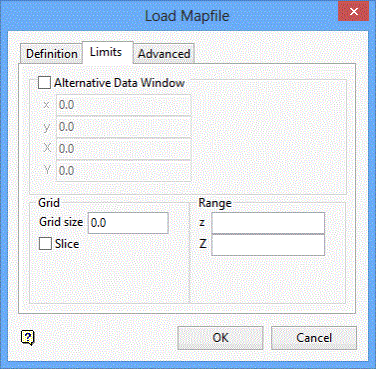
Alternative Data Window
Enter the window extents. Points falling outside of the window region are not loaded. This will also be the default window during modelling. The lowercase x and y are the minimum X and Y (Easting and Northing) coordinates the uppercase X and Y are the maximum X and Y coordinates.
You can leave these fields blank, in which case all of the data are loaded. If you do include window extents, then they are included in the replay file (replay.gdc_cmnd).
Grid size
Enter the default grid size to be used during modelling.
When loading a map file using Load Mapfile, it is important to specify the grid size on the Limits tab which will be used for modelling. Failure to do so may result in systematic errors in the modelling results due to a coordinate transformation that is applied to the data at the time of loading.
If you want to perform modelling with a different grid size than was specified during the loading of the data, it is best to first clear the data and reload in the desired grid size.
Slice
Select this check box if you only want to load the value (interpolated or real) of string data at grid line intersections. This can be used to reduce the amount of data loaded (although it can increase it if the grid size is small). This option should only be applied to string data types.
This check box must be checked when the spline modelling method is to be used on the data. Refer to the Grid Model option (under the Grid Calc > Model submenu) for information on the spline modelling method.,/p>
Range
Enter the Z extents. Points with Z values falling outside of the specified range are not loaded. You can leave these fields blank, in which case all of the data are loaded. If you do include window extents, then they are included in the replay file (replay.gdc_cmnd).
Advanced tab
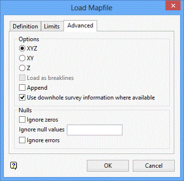
Options
XYZ
Select this option to load a new set of X, Y, and Z values.
XY
Select this option to load a new set of X and Y values. The Z values will be set to '0'.
Z
Select this option to load a new set of Z values. The Z values are merged with the current set of X and Y values. If the merge is successful, that is, if every X and Y value receives a new Z value, then the current triangulation is left intact.
Load as breaklines
Select this check box to load the data as breaklines. Triangles cannot form across breaklines. Therefore, if the triangulation modelling method is used, the grid will honour these lines.
Append
Check this box to append the data to the current set of data. If this check box if not selected, the current set of data will be cleared first.
Use downhole survey information where available
Select this check box to load downhole survey information if it is present in the mapfile. If this check box is ticked, then Grid Calc will search for TOPX, TOPY, MIDX, MIDY, BOTX, BOTY in preference to EAST and NORTH under the following circumstances:
-
When loading the 'SR' variable, 'TOPX' and 'TOPY' will be used
-
When loading the 'SF' variable, 'BOTX' and 'BOTY' will be used
-
For all other variables, 'MIDX' and 'MIDY' will be used
Nulls
Ignore zeros
Check this box to exclude data points with zero Z values from the load.
Ignore Null values
Enter the null value. Data points with a Z value equal to the null value will be excluded from the load.
Ignore errors
This inhibits flagging of read errors (such as those caused by non-standard comments in a mapfile).
Click OK.
The Mapfile is then loaded.

