Horizon Table
Use the Horizon Table option to set topography, horizons and crop layers.
The Horizon table names each horizon and specifies its priority. Horizons are specified in top down order, that is, horizons near the surface are specified first, then those deeper in the ground. This order is critical. A model is built off a base horizon. The modelling adds thicknesses, both upwards and downwards, to generate the other horizons. Horizons that are of "equal" priority, in particular the merged portion of two splits, can be specified either prior to, or subsequent to, the splits. The order in this case is not important.
Each horizon can have a "crop layer". A crop layer is a layer in a design database that contains limiting polygons for a horizon. The polygons are not limited to crop lines, but should define the physical extent of each horizon. In the case of splits, the lines will also define the extent of each split. These limit polygons can be determined in a variety of ways. Sometimes it is necessary to run a model without limiting seams, and then use contour lines (for example, thickness of overburden) to determine the extent.
The topography is stored in the <proj><area>.gdc _spec file. The horizons are stored in the <proj>.gdc_glob file. If the Geology > Drilling Utilities submenu was used to generate mapfiles, then the horizon table will already exist.
Instructions
On the Grid Calc menu, point to Edit Modelling Defaults, and then click Horizon Table to display the Horizon Table panel.
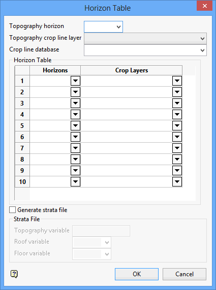
Topography horizon
Enter, or select from the drop-down list, the name of the topography variable.
Topography crop line layer
Select the layer that contains the masking polygon(s) for the topography surface. Wildcards (* multiple character and % single character) may be used.
Crop line database
Select the design database that contains the cropping polygon(s).
Horizons
Select the horizons, from shallowest to deepest.
Crop Layers
Enter the name of the crop layers from the crop design database. These are individual layers containing horizon extent polygon(s). A common polygon layer may be used for all horizons. Wildcards may be used.
Generate strata file
Select this check box to generate a strata file. A strata file is used by the Range Diagram and Section Design modules in Vulcan. Any existing strata files will be overwritten. As an existing strata file may contain additional information to that written by Grid Calc, you should exercise caution when overwriting these files.
Strata File
Topography Variable
Specify the topography variable.
Roof Variable
Specify the structure roof variable (usually SR).
Floor Variable
Specify the structure floor variable (usually SF).
Click OK.
The horizons and topography are then set.
Use the Save Grid Specifications option to save the horizon table.

