Define Level Grid
Use Define Level Grid to define a new grid. This command is used to create a grid of constant value such as a known elevation, or as a base for a grid that is to be derived using a mathematical expression. For example, use this option if you need to create a grid that represents a precise plane such as a mining bench.
Instructions
On the Grid Calc menu, point to Grids, and then click Define Level Grid to display the Define panel.
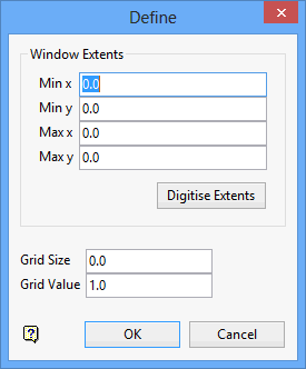
Window Extents
The extents can be entered manually, digitised or left blank. If left blank, the values defined through the Specifications panel will be used instead.
To digitise the extents:
- Select the Digitise Extents button.
- Indicate the lower left corner of the grid. Drag the rectangle that appears to the upper right corner of the grid and click once to complete digitising the extents.
The coordinates of the extents are displayed in the panel. You can alter these values if necessary. For example, you may want to round the values to two significant figures).
Grid Size
Enter a value for the spacing between the grid nodes. Again, default values (from the Specifications) will be used if no value is specified.
Grid Value
Enter the constant value with which to fill the grid. After the grid has been created, each grid node will have this value. All grid nodes will have a mask of 1 (one) and will be visible. If you are creating a mining bench, then this value will be the elevation of the bench.
Click OK.
The grid is then created.
To display the grid, use the Static Display Grid or Dynamic Display Grid options (under the Grid Calc > Display submenu). You can also type one of the following two commands at the Grid Calc command line:
plot plot_grid

