Mapfiles
General Information
The standard mapfile file name has the following form <proj><mfi>.map.
The <mfi>, mapfile identifier, is the horizon name. It is sufficient just to use the mfi when referencing mapfiles in the current project.
The standard mapfile is designed to store information relating to subsurface strata. The information contained in the columns is fixed. In the case of the standard mapfile, knowledge of the listed codes is sufficient to access the data in the file. These mapfiles are best generated using the Geology > Drilling Utilities > Mapfile Build Macro option.
Non-standard mapfile formats can also be accessed in Grid Calc if required. Refer to the Define Variables option (under the Grid Calc > Edit Modelling Defaults submenu) for more information.
Mapfile Codes
Standard name and mapping variable codes for mapfiles are as follows:
|
Name |
Description |
|
LC |
location of collar |
|
SR |
elevation of the structure roof. |
|
SF |
elevation of the structure floor. |
|
DR |
depth to the structure roof from the collar. |
|
DF |
depth to the structure floor from the collar. |
|
TK |
thickness of product between the structure roof and floor |
|
ST |
structure thickness - total thickness of all material between the structure roof and floor. |
|
PT |
parting thickness - thickness of waste material between the roof and floor. |
|
OB |
overburden - thickness of structure roof to collar, if there are no overlying structures. |
|
MD |
midburden - thickness from the current structure roof to above structure's floor, if existing. |
|
TP |
topography surface. |
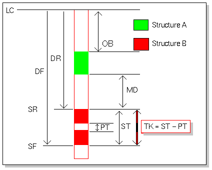
Figure 1: Mapping Variable Definitions

