Create Stacking Macro
Use Create Stacking Macro to build a Grid Calc macro file containing all the necessary operations to build a consistent stratigraphic model of a deposit.
The macro is stored as a file named:
<proj><macro_name>.gdc_cmnd
An associated file, which contains all of the output gridding information, is automatically created when the macro is executed. This file is named:
<proj><macro_name>.gdc_list
Both files will be placed in your working directory.
Instructions
On the Grid Calc menu, point to Macros, and then click Create Stacking Macro to display the Create Model Macro panel.
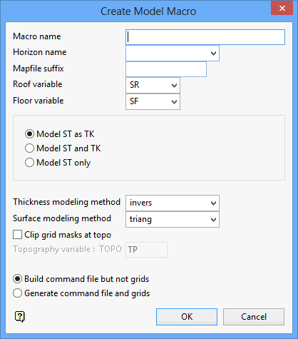
Macro name
Specify a name for the macro. This forms the <macro_name> part of the macro file.
Horizon name
Enter the starting horizon. The macro builds the grids from the floor of the starting horizon working both up and down. The starting horizon may be any one of the horizons appearing on the left of the split table (the <proj>.gdc_glob file contains the split table). It is best to choose a horizon with the best natural definition. Try to avoid choosing a horizon for which there is little original data. As the effect of choosing one horizon over another is minimal, the decision will not 'make-or-break' the modelling process.
Mapfile suffix - Optional
This field is used to allow you to access an alternate set of mapfiles, particularly those created using Fixmap. Mapfiles are typically named <proj><horizon>.map (for example, abch.map). Fixmap mapfiles have a Z suffix (for example, abch z.map). Specify Z in this field to access Fixmap mapfiles.
Roof variable
Enter the name of the roof variable. The standard name for the roof variable is SR. You are required to specify the variable names for both the roof and floor grids. This affects the names of the grids created and it may also affect the manner in which the raw data is read.
Floor variable
Enter the name of the floor variable. The standard name for the floor variable is SF.
Model ST as TK
Select this option to model the structure thickness (ST) as the material thickness (TK). This option creates one thickness grid (TK), that is inclusive of all materials between SR and SF (that is, it is the ST grid). Use this option to report a single volume (that is, it assumes the whole seam is to be mined and the parting is non-separable).
Model ST and TK
Select this option to model the structure thickness (ST) and the material thickness (TK). This option creates two thickness grids. TK excludes the parting thicknesses as recorded in the mapfiles. Use this option to report material volumes as distinct from structural volumes.
Model ST only
Select this option to model only the structure thickness (ST). This option creates one thickness grid (ST), that is inclusive of all materials between SR and SF. Use this option to report structural volumes, but don't want to confuse the term ST with TK.
Note: The Model ST as TK and Model ST only options are nothing more than naming choices. It is up to you to choose a naming scheme that is consistent and understandable at a later date.
Two modelling methods are required to build a model. The modelling methods are described in detail in the Model option documentation.
Thickness modelling method
Select the method to use to model stratigraphic thicknesses. The model is built by adding thicknesses to the floor of the starting horizon. The thickness modelling method defaults to inverse distance. Inverse distance is "well-behaved" and models thicknesses quite well. Alternatively, you could use triangulations without trending. Regardless of the method chosen, the macro forces all thicknesses to be non-negative. Deposits containing very thin horizons or burdens should not be modelled using the inverse distance method.
Surface modelling method
The chosen surface modelling method is used once to model the floor of the starting horizon. The method used should offer suitable extrapolation capabilities and must be tested and validated by you if correct results are to be obtained.
Clip grid masks at topo
Select this check box to clip the modelled grids at the topography. This does not alter the node values, just the mask values. You may achieve the same results by using the Clip Grids option once the grids are built.
Topography variable
Specify the two letter topography variable that will be used to identify the topography grid. The resulting grid will be named <proj>topo.<topography_variable>g.
Build command file but not grids
Select this option to create the model macro command file without generating the grids. The macro can then be invoked at a later stage by issuing the command:
@<proj><macro_name>
on the command line (for example, @abcgrids) or by using the Invoke Macro option. This to edit the macro created and customise it if required, for example, differing modelling methods for certain horizons, fault modelling, or the incorporation of design data.
Generate command file and grids
Select this option to create the model macro command file, the accompanying <proj><macro_name>.gdc_list file, and the grids. It is useful to have a Report Window open at this time to be able to follow the progress of the modelling run.
Click OK.
The macro command file is generated and saved. If selected, the grids are also generated.

