Offset Distance
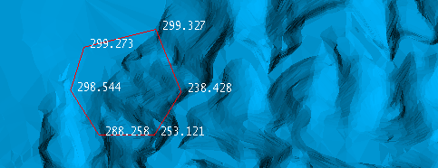
This option will calculate the Z elevation difference between a line and a surface triangulation at every point of the line and store it in the point name. The option will also save the information in a CSV file.
On the Model menu, point to Triangle Surface, then click Offset Distance to display the following interface.
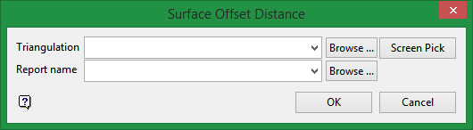
Triangulation
Select a triangulation from the list, or click Browse to choose one from a different location. You may also select one from the screen by clicking Screen Pick.
Report Name
Select a file from the list, click Browse to choose one from a different location, or enter a new name for the file.
Instructions
-
Make sure the surface triangulation and polygon are loaded onto the screen.
-
Select the triangulation and report name on the Surface Offset Distance panel.
-
Click OK.
-
Select the method you want to use to select the polygon, then select it from the screen.
-
Right-click to close the selection process, and again to close the context menu.
-
The distance will be displayed at each point of the polygon.
Output results
CSV report

Results shown as point names