Local to UTM
Convert Local Grid Coordinates to UTM Projection Coordinates
The Local to UTM option to convert individual local mine grid coordinates to Universal Transverse Mercator (UTM) map projection coordinates. The conversion will use the loaded transformation (stored in the <proj>.env_tran file) specified in the Set Up Local option. The converted coordinates are displayed in the Report Window.
The Local to UTM option only allows the coordinates of a single point to be transformed at a time. To transform objects or entire layers to the new grid system, use the Design > Transformation > Matrix option.
![]() Note
Note
The Local to UTM option can also be used to convert local mine grid coordinates to any other conformal coordinate grid system (other than UTM). For example, to transform local mine grid coordinates to another plane grid.
Instructions
- Select Survey menu
- Select Transformations submenu
- Select Local to UTM option
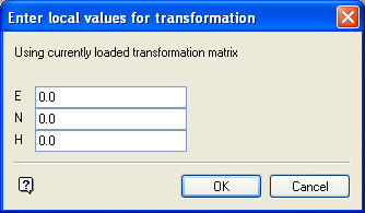
The following panel displays.

Enter local values for transformation panel
Easting/Northing/Height
Enter, in real world units, the grid coordinates to be converted.
Select OK.
The converted coordinates are displayed in the Report Window.
![]() Note
Note
The results of the above calculation will automatically be passed to the UTM to Lat/Long panel if that option is selected immediately after the current conversion (Local to UTM).

