Appending Survey Data to Triangulation
These notes describe how to update existing as-built data (For example, sill polygons and 3D solid triangulations) with new survey information. The notes assume that the survey method consists of points along the rib, back and sill and that the survey instrument is being used in conjunction with the TDS > Survey Link option. The notes also assume that there are two design database files (.dgd files) each beginning with the project name:
<proj>asbuilt.dgd
This design database file contains cleaned up survey jobs, layers are organised by level, everyone has access to this file and it is maintained by surveyors.
<proj>survey.dgd
This design database file contains imported survey jobs (via TDS > Display ), layers may be organised by job, only the surveyors work with this file.
We recommend that you maintain the data as components.
Example: Ramps will be broken down by level, access development will be organised by a naming system, For example, stope number etc. If the names of the layers and triangulations are kept consistent, simple wildcards will quickly bring this data on the screen.
The steps involved when appending survey data are:
- Open the design database file containing all the survey work ( File > Design Files > Open ).
- Import the survey job into the survey design database file ( TDS > Display ). Save the job ( File > Save ). The imported data is shown on the screen.
If the as-built you are working on is new, then go to step 3.
If you are appending to an existing as-built, go to step 6.
- Verify your data. For example, roof/back and floor/sill surveys cannot go beyond the X/Y extent of the wall/rib line for the next steps to work. If a survey extends beyond the wall/rib line, then consider using the Design > Relimit > To A Point option to bring the point in the bounds of the wall/rib line. Visually check for other busts. Be sure to rotate the data, looking for busts in elevations.
- Create the 3D polygons and triangulation via the Build 3D Drive option. Once created, save your work ( File > Save ).
- "Publish" the survey data by importing the 3D as-built polygons that have been created by the Build 3D Drive option, into the as-built design database file. This is best done by saving your work in the survey design database file, then opening the as-built design database file. While remaining in the as-built design database file, list the layers from the survey design database file ( File > Layers > List ). From the list, select the as-built layers upon which you have been working. If you are prompted to replace an existing layer, select replace to update the as-built. Save your work and exit.
If you are appending to an existing as-built, then continue with step 6.
- Bring up previous jobs (for the given area of interest) with the File > Layers > List option. You will see on the screen both the new job and the previous job(s).
- Update the survey job as-built wall/rib, originally created in step 2. Using the Design > Point Insert > Replace String option, select the portion of the current as-built wall/rib line to be replaced/updated with the new survey. The point order of the line is important. You must always pick the first and last point in the direction of the point sequence. If you don't, then you will destroy part of your as-built. If this accidentally happens, then use the Design > Undo option. To determine point direction, use the Analyse > Label > Point Label option.
Note: Use the Replace String option if you are replacing more than one line segment. Use the Design > Point Insert > Insert option if you are replacing just one line segment.
This update portion of the procedure is likely the most involved. In addition to the Replace String and Insert options, you may also need to use Design > Point Edit > Move option and other related CAD functions. If you find yourself using a lot of these items, and find it bulky to select your most commonly used options, then consider using hot keys or designing your own toolbar. Refer to the Tools > Customise option for more information.
- Make the completed, up-to-date as-built wall/rib line invisible using the Invisible button (
 ) on the Visibility toolbar. This will expose the most recently imported wall/rib line. Remove this wall/rib as it is no longer needed because its information has now been integrated into the maintained as-built.
 - Save your work ( File > Save ).
Note: If you have followed the above steps, then the first survey job for a given area of interest (that is, the as-built on which you are working) will now store the ENTIRE wall/rib line for the area of interest, inclusive of all subsequent survey jobs. For this reason, you may want to rename the layer a more general name ( Design > Layer Edit > Name ). At this time, the first survey job will also store the roof/back and floor/sill shots for THAT first job. Also at this time, each subsequent survey job will store only the roof/back and floor/sill survey shots for those subsequent jobs. This situation will change in step 11.
- Verify the data (see step 3) and then return here.
- The Build 3D Drive option currently requires the roof/back and floor/sill survey shots to be contained in one object. Once you have checked that the transition from one survey job to the next looks okay at the roof/back and floor/sill (if not, make the changes as needed, as this data defines the final shape of the as-built), then combine multiple survey objects into one using the Design > Object Edit > Coalesce option. Make sure that you choose to replace the old objects with the new one! The one as-built wall/rib line and the one roof/back survey and the one floor/sill survey will be used to create the final shape of the 3D as-built.
Note: If you have many points and/or lines for the roof/back and floor/sill shots, instead of using the Coalesce option, use the Design > Layer Edit > Unify option.
- Create the 3D polygons and triangulation via the Build 3D Drive option. When using this option, you will select one wall/rib line and multiple roof/back and floor/sill shots, each of which are stored as one object, which means that you are actually also picking one roof/back survey and the one floor/sill survey. Overwrite the previous triangulation of the as-built on which you are working. Save your work ( File > Save ).
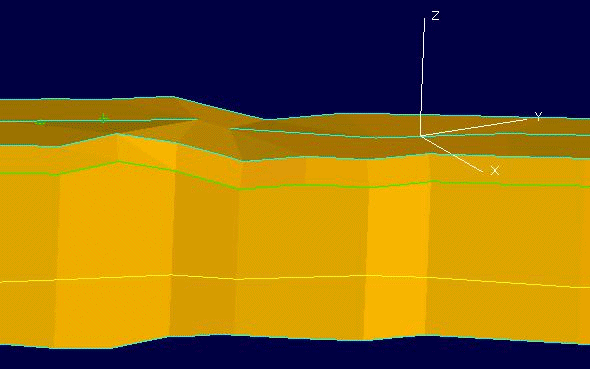
You might want to look quickly at the finished product to check for any busts. For example, in the following image, is the drop in elevation, seen in the roof/back, between the two survey jobs acceptable? If not, then you would have to return to step 11.
- Drop in Elevation
- Import the updated as-built data into the as-built design database file as in step 5.
Engineers and others can obtain required data via group selection. For example, they can display the as-builts on the screen, showing both the roof/back and floor/sill data. They can then make the roof/back polygons invisible, selecting by group using the View > Visibility > Design Visibility option.
In the case of the as-built (on which you are working) branching off of a main drift, you may decide to start an entirely new as-built as part of your organisation scheme. This is in fact recommended. When you do this, please ensure that the points perfectly match where the new as-built connects to the other. There should be no gaps or overlap. If the connection is not perfect, then possible future volumetrics and reserving programs will be slightly inaccurate.
As a variation of the above steps, you could apply the CAD tools (Design > Point Insert, etc.) used with the survey job wall/rib data to the lines created by Build 3D Drive. In this scenario, you would maintain the lines/polygons at the roof/back and at the floor/sill. To create triangulations, you would then use the Model > Triangle Solid > Create option. For a given situation, you might also find the Triangulate Level option to be helpful. This option allows one to create a surface triangulation that honours the wall/rib extents and elevation and honours the roof/back (or floor/sill) survey data.

