Creating a Scan Average
Scans can be averaged to improve the measured distance accuracy of the scan or to remove foreground objects (e.g. vehicles from busy road).
Note: Scans must have the same set up, for example the same azimuth and elevation, to be able to successfully perform an average.
Note: The accuracy improvement is an inverse
square relationship to the number of scans: i.e. 4 scans = 1/(square root
of 4) = 1/2 = 50% improvement.
-
Highlight the scans to be averaged in the project explorer.
-
On the Create ribbon tab navigate to the Scan group and select
 Scan Average.
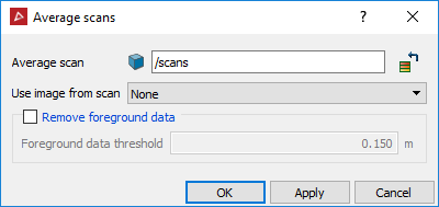
-
Specify the location to save the averaged scan in the Average scan field.
-
Select a scan from the Use image from scan drop-down list to associate an image with the averaged scan. Select None to have no images associated with the averaged scan.
-
Set the Foreground data threshold to remove traffic or pedestrians from the scan data. The threshold value determines how far in front of the background an object must be before it is removed.
-
Click OK or Apply.
The scan is created from the selected scans and averages the range data at each grid location. This is equivalent to the averaging functionality for multiple passes taken using the Maptek scanner.