Create Textured Surface
Source file: create-textured-surface.htm
To create a textured surface, click on the ![]() Create Textured Surface button on the Photogrammetry ribbon tab, then follow the steps below.
Create Textured Surface button on the Photogrammetry ribbon tab, then follow the steps below.
-
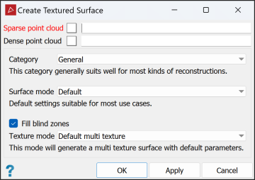
Select required sparse and dense point clouds in the project explorer. These will be automatically added to the appropriate fields in the panel.
Tip: If you select a point cloud in the project explorer before clicking the textured surface tool, it will automatically be added to the Dense point cloud field.
-
Select the required Category (refer to Creating a Dense Point Set):
-
Select the Surface mode:
Surface Mode Applicable categories Applicable categories Preview Default settings with no photoconsistency optimisation. General, Aerial/Nadiral, Urban, Surface scan Default Default settings suitable for most use cases. General, Aerial/Nadiral, Urban, Surface scan High details Increased resolution during the photoconsistency optimisation. Requires more time and produces a surface with more facets. General, Aerial/Nadiral, Urban, Surface scan, Vertical structure Ultra Maximum resolution during the photoconsistency optimisation. Requires much more time and produces a surface with a lot of facets. This mode should be used only in very specific cases. Surface scan, Vertical structure -
When, Fill blind zones is selected, the textured surface tool will add points to fill in any areas not visible to any cameras. Clear this option if you don't want these points to be added.
-
Select the Texture mode:
Low facet count This mode will generate a simplified, single textured surface with reduced storage size. Default single texture This mode will generate a single texture surface with default parameters. Default multi texture This mode will generate a multi texture surface with default parameters. High details
This mode will generate a multi texture high resolution surface.
Note: This is the only texture mode available for the Vertical structure category.
-
Click OK or Apply.
| General | This category generally suits most kinds of reconstructions well. |
| Aerial/Nadiral | Use this category when you are reconstructing a top-down view scenario, typically a UAV drone-acquired dataset. |
| Urban | Use this category when reconstructing buildings, façades or scenarios that are shot in an urban setting. You can use this category for small objects instead of the Surface scan category if you are mixing different types of photos, especially if the whole dataset is not shot from the same distance. |
| Surface scan | Use this category when you are reconstructing surfaces close up (e.g. terrain or ground). |
| Vertical structure | Use this category when you are reconstructing telecommunication towers or other thin vertical structures from drones. |
