Link 
Link Strings
Use the Link option to create new strings by linking existing strings that are in a user defined distance of one another. The original strings remain unchanged.
This option is useful for underground survey data where a great number of strings may exist. Combining the strings into larger strings makes it more manageable.
This option can also be accessed by selecting the Link button ![]() from the Merge toolbar. The Merge toolbar is a "sub toolbar" and can either be accessed through the Modify toolbar or through using the Toolbar Visibility option (under the Tools menu).
from the Merge toolbar. The Merge toolbar is a "sub toolbar" and can either be accessed through the Modify toolbar or through using the Toolbar Visibility option (under the Tools menu).
Instructions
On the Design menu, point to Point Edit, and then click Link to display the Link Strings panel.
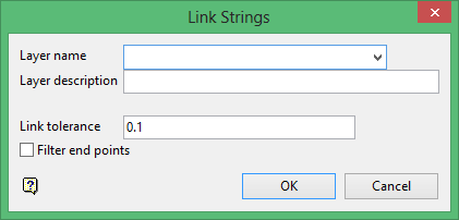
Layer name
Enter, or select from the drop-down list, the name of the layer in which the new strings will be assigned. The maximum size of the layer name is 40 alphanumeric characters (spaces are not allowed).
Layer description
Enter a description to further describe the contents of this layer. The description can be up to 80 alphanumeric characters and may include spaces. If a description is not entered, then a default description will be used instead. If the chosen layer already has an assigned description, the description displays when the layer is selected. Existing layer descriptions can be overwritten.
Link tolerance
Enter, in real world units, the maximum distance the strings can be apart and still be linked. The default value is set to 0.1.
Filter end points
Select this check box to omit the end point of the first object from the resulting string. If unticked, then the end point will be included. We recommend that you enable this check box when using a small tolerance where the end points for the strings are assumed to be coincident.
Click OK.

