Geographic
Perform a Grid/Spheroid Conversion
The Geographic option to convert coordinates of selected objects from:
- Australian Map Grid (AMG), Integrated Survey Grid (ISG), World Geodetic Systems (WGS 84) and Map Grid of Australia (MGA) to latitudes/longitudes and vice versa.
- AMG to ISG and vice versa.
- Zone changes on overlapping zones for AMG.
This option uses Redfearns Formulae to perform a direct conversion of the coordinates. Both AMG and ISG are based on the same spheroid, which means that you can convert freely from AMG to ISG. However, this option does not convert from AMG or ISG to MGA. Use the GDA Conversion option to convert AMG of ISG to MGA.
Useful websites are:
- Geoscience Australia Geodesy & GPS
- ANZLIC
Instructions
- Select Design menu
- Select Transformation submenu
- Select Geographic option
The following panel is then displayed.
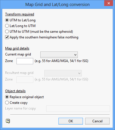
Map Grid and Lat/Long conversion panel
Transformation required
UTM to Lat/Long
Select this option to convert map grid coordinates to geographical coordinates. You will need to specify, through the remainder of this panel, the current map grid and zone.
Lat/Long to UTM
Select this option to convert geographical coordinates to map grid coordinates. You will need to specify, through the remainder of this panel, the resulting map grid and zone.
UTM to UTM
Select this option to convert AMG to ISG or vice versa, or to change zones for AMG (this is normally used in zone overlaps). You will need to specify, through the remainder of this panel, the current and resulting map grid and zone. If the zone has a slash, then it is assumed as being ISG.
Apply the southern hemisphere false northing
When converting between UTM grid coordinates and latitudes/longitudes, check this box to apply the southern hemisphere UTM false northing. This needs to be applied if using coordinates in the southern hemisphere only. If this box is checked, it will modify the northings to give correct calculations on data in the southern hemisphere.
Map Grid details
Current map grid
Enter, or select from the drop-down list, the current map grid zone. Map grid zones are entered as an integer for AMG (between 49-56) and as an integer plus a forward slash and the number 1, 2 or 3 for ISG (between 54/2 - 56/2). This is only applicable for UTM to Lat/Long or UTM to UTM transformations.
Resultant map grid
Enter, or select from the drop-down list, the resulting map grid zone. This is only applicable for Lat/Long to UTM to UTM transformations.
Object Details
Replace original object
Select this option to perform the transformation on the original object.
Create copy
Select this option to perform the transformation on a copy of the object. Specify the layer name for the transformed objects.
Select OK.
The Multiple Selection box is then displayed. Use the Multiple Selection box to choose your method of selecting the objects and select the objects. The Multiple Selection box will be redisplayed in case you want to select more objects for transformation.
Data that has been converted will have different coordinates and will not be visible in the current window. Use the View > Windows > Fit Layer option to create a new window in the correct coordinate range. You should then be able to see the converted data.

