Data Tips
Define Data Top Information
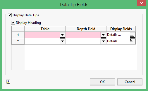
Use Data Tips to define what fields you want to appear in data tips when hovering over a drillhole. Settings configured through the Data Tips option will be stored in a Data Tips specification file ( . dts ). The specification file will be stored in your current working directory and will be named after your geological database.
For example, i f your database is texdrilling.geo.isis , then the Data Tips specification file will be named.
Note: The selected tables must have aBottomDepth and aTopDepth synonym attached to two of its fields for the data tip to appear. Refer to the Database Elements section for more information about synonyms.
Instructions
On the Geology menu, point to Drilling, and then click Data Tips.
Select a drillhole displayed in the Vulcan Window. The following panel is then displayed.
Display Data Tips
Select this check box to display data tips when hovering over this drillhole or other drillholes from the same database.
Select the Display Heading check box to view drillhole information, such as the drillhole name and depths, as a header in the displayed data tip. In the following diagram, the data tip on your right is displaying the heading information while the data tip on your left is not.
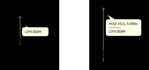
Figure 1 : Data Tip Headings
Table
Enter, or select from the drop-down list, the table type to be displayed from the selected Display Field.
Depth Field
Enter, or select from the drop-down list, the field containing the bottom depth information, for example "TO" in "Geology".
Display Fields
Click ![]() to choose the fields that you want to include in the data tip. Once selected, the following panel displays.
to choose the fields that you want to include in the data tip. Once selected, the following panel displays.
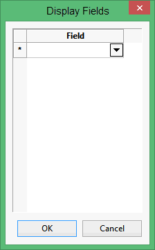
Select the necessary fields from the drop-down list. Click OK when you are ready to return to the Data Tip Fields panel.
Click OK.
The chosen fields displays when you position the mouse cursor over drillholes from the same drillhole database.

