Intersect
Display Drillhole Intersection Points
Use the Intersect option to display and highlight the points at which a drillhole intersects a triangulation or specified elevation. This allows you to plot intersections of drilling with underground openings.
The intersections are stored as points with each point being considered an object. With each point/object, the following information is stored:
-
Object and point name
This is the name of the drillhole from which it came. -
Object value
This is the downhole depth from the collar to where the hole intersects the triangulation or specified elevation. The Analyse > Label > Object Label option can also be used to label the intersection points.
Note: If a drillhole intersects with a triangulation on multiple occasions, then each point will be stored under the same name, but with different values reflecting the different downhole depths.
Instructions
On the Geology menu, point to Drilling, and then click Intersect to display the Layer for intersection points panel.
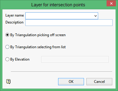
Layer name
Enter the name of the layer that will be used to store the intersections.
Description
Enter a description to further describe the contents of this layer. The description can be up to 80 alphanumeric characters and may include spaces. If a description is not entered, then a default description will be used instead. If the chosen layer already has an assigned description, the description displays when the layer is selected. Existing layer descriptions can be overwritten.
By Triangulation picking off screen
Select this option to pick the required triangulation directly from the screen. If there is only one triangulation loaded onscreen, then it will be selected automatically.
By Triangulation selecting from list
Select this option to pick the required triangulation from a list. The triangulation will be selected through the standard Open panel, which displays after you have completed the Layer for intersection points panel. The Open panel will allow you to browse through your available data directories and supports the use of wildcards (* for multiple characters, % for a single character) to limit the items displayed with the list.
By Elevation
Select this option to nominate a horizontal plane instead of a triangulation to intersect with the drillholes.
Click OK.
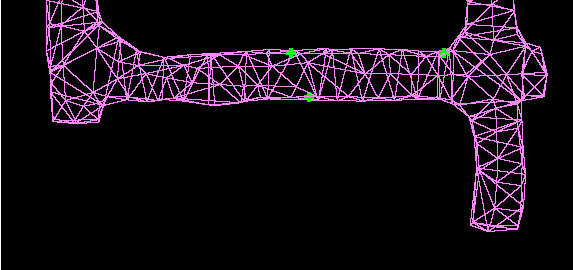
Figure 1 : Drillholes Intersecting a Triangulation
Tip: For a clearer view of the intersection points, remove the drillholes from the screen using the Remove Drillholes option.

