Display
Use the Display option to define how the polygons obtained from the optimisation are to be loaded.
Instructions
On the Open Pit menu, point to Dig Limits, and then click Display.
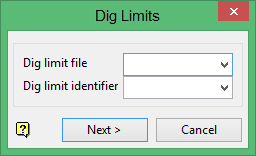
Dig limit file
Enter, or select form the drop-down list, the name of the specification file that you want to open. The available drop-down list contains all of the.dg1 files found within your current working directory.
Dig limit identifier
Enter, or select from the drop-down list, the name of the parameters identifier that you want to load. The available drop-down list contains all of the identifiers found within the selected specification file.
Click Next.
The following panel displays.
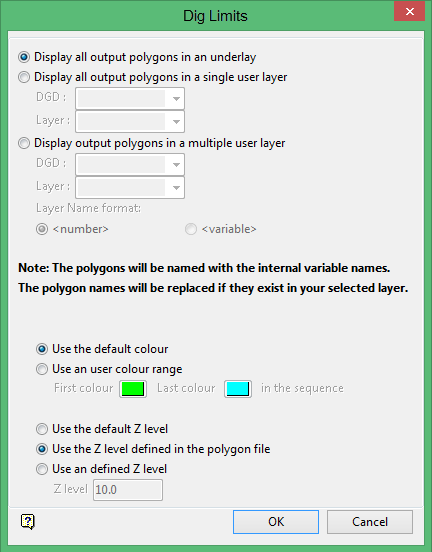
Display all output polygons in an underlay
Select this option if you want to display the polygons within an underlay.
Display all output polygons in a single layer
Select this option if you want to display the polygons within a single layer. You will need to select a design database and layer from the drop-down lists.
Display all output polygons in a multiple user layer
Select this option if you want to display the polygons within separate layers. You will need to select a design database and layer from the drop-down lists, as well as define the layer name suffix.
Display the polygons when the optimisation process is finished
Select this check box if you want to display the polygons as soon as the optimisation process has finished.
Use default colour
Select this option if you want to display the polygons using the default colour (defined through the Status toolbar).
Use an user colour range
Select this option if you want to display the polygons using a nominated colour range.
Use the default Z level
Select this option if you want to display the polygons at the default Z level (defined through the Status toolbar).
Use the Z level defined in polygon file
Select this option if you want to display the polygons using the Z level contained within the polygon file (.pol).
Use an defined Z level
Select this option if you want to display the polygons at a specific Z level.

