Tritronics
Create a mapfile in the Tritronics DrillNav Plus Mapfile format
The Tritronics option to create a mapfile in the Tritronics DrillNav Plus Mapfile format. The blast hole objects are placed in the CSV mapfile (extension
.map
) as point objects 'PO' records.
The report consists of PO, hole name, easting, northing, bottom RL, instruction field, hole bearing (from bottom to top), mast angle (from vertical) and the top RL.
Note To include the top RL in the report, you must check the Include top of hole elevation check box on the Tritronics Mapfile Parameters panel.
It is also possible to add line objects (strings). The information about these objects will appear in the report after the point object information and is in the following format:
line type, easting and northing
where line type is one of:
- LS - start of line
- LN - middle of line
- LE - end of line
To use this option, the holes and the boundary containing the holes must be displayed on the screen. This mapfile can be placed in any directory.
Note The Tritronics option does not support the Input intervals method.
Instructions
- Select Open Pit menu
- Select Hole Design submenu
- Select Tritronics option
Select the boundary. You will then need to confirm your selection.
If you haven't set the default method for designing holes, then the Create Holes panel displays before you are asked to select the boundary polygon.
The Multiple Selection box is then displayed. From this box, select the method for selecting the blast pattern. Cancel when you have finished selecting the blast pattern.
The following panel is then displayed.
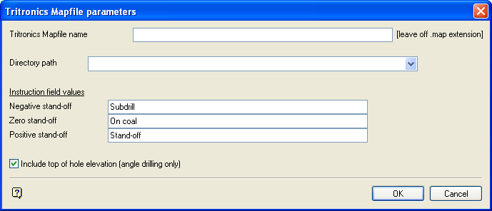
Tritronics Mapfile Parameters panel
Tritronics Mapfile name
Enter the name of the mapfile. The
.map
file extension will be added automatically.
Directory Path
Enter the path to the directory in which you want to save the mapfile. If you want to save it in your current working directory, then enter a decimal point, that is, '.'.
Instruction Field Values
Enter the instruction field values for the Negative stand-off, Zero stand-off and Positive stand-off. These text entries displays in the instruction field section of the mapfile.
Include top of hole elevation (angle drilling only)
Select this check box to include the top of the hole elevation in the report.
Select OK.
You will then be re-prompted for the selection criteria for exporting blast pattern to Tritronics. Cancel if you have finished selecting the blast pattern.
You will then be prompted for the selection criteria for exporting strings to Tritronics. Cancel if you do not want to select string objects. Otherwise, choose your method for selecting the string objects. Cancel when you have finished selecting objects.
Once all of the objects have been selected (points and optionally strings), the mapfile is generated. It is placed in the directory you specified on the Tritronics Mapfile Parameters panel and displays in the Report Window.
The diagram below is of a Tritronics Report, showing point objects with the top of hole elevation included. From the left to the right the fields (separated by commas) are PO, hole name, easting, northing, bottom RL, instruction, hole bearing (from bottom to top), mast angle (from vertical) and top RL.
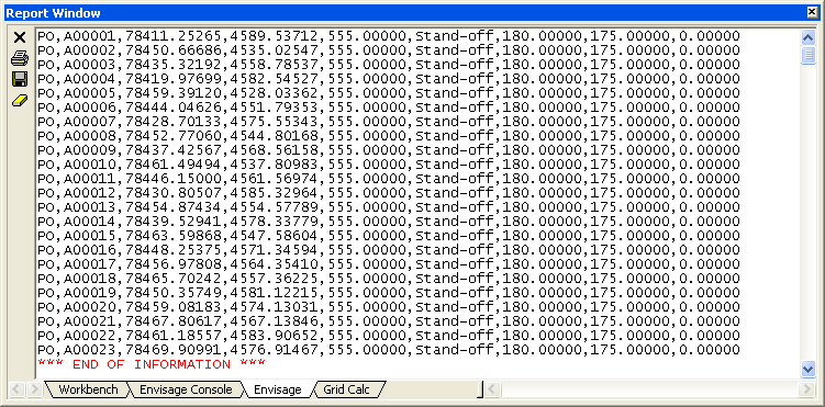
Diagram 1 - Report Window Output

