Strat Profiles
Generate Stratigraphic Profiles
The Strat Profiles option to generate stratigraphic profiles along any of the created section lines or a long section line. A stratigraphic file ( <proj>strata.hzl ) must exist it is used to obtain a list of possible surfaces to profile. This file can be created through the a text editor.
Note: If you used Grid Calc to build the geological model, then you can generate the strata file from in Grid Calc. Refer to the Grid Calc > Edit Modelling Defaults > Strata File option for more information.
The Report Window of Vulcan will list the surfaces being used.
Instructions
- Select Open Pit menu
- Select Section Design submenu
- Select Strat Profiles option
The Select dialog box displays. From this box, select whether you want to profile only selected section lines, all of the section lines (in the current working layer), or just the long section line.
Upon selection of one of the above options, the Select horizons to profile panel displays.
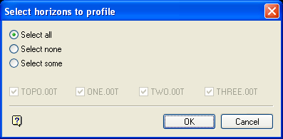
Select horizons to profile panel
This panel reflects the topography and the table of conformable surfaces from the stratigraphy file.
All the horizons are listed. If you want to profile all, then select the Select all option. All horizons are then automatically checked (this is the default). If you want a selection of horizons, then select the Select some option and clear the horizons that are not required.
Select OK.
You will then be prompted to select a section line(s) or a long section line along which you want to generate the stratigraphic profiles. Once selected, the profiles are generated using the surfaces selected from the panel.
The method of profile generation is as follows:
For each surface, the section line or long section line is registered vertically to the surface. If a profile for this surface already exists for this section line, then the old profile is replaced by the new one.
- If the stratigraphy file includes a mask string for this surface, and the mask string's layer is in the current database, then this string is used as the mask. If not, and the surface is a grid, then the grid mask is used. The effect of masking is to clip the profile string to the mask, following the standard inclusion and exclusion rules.
- If the stratigraphy file contains a
PLOT_ATTRIBUTEStable, and there is an entry for this surface, then the profile object will use the colour from this table.
To view the profile, use the Section View option.

