Graphical Attributes
Use Graphical Attributes to set the graphical attributes, such as colour, line type and pattern of objects, in the currently open working layer.
The objects may be drivages, panels, roadway scheduling blocks, pillar scheduling blocks, longwall/shortwall scheduling blocks, long-term reserve blocks and outlines. Outlines are used for plotting purposes.
The graphical attributes are stored in a file named '[att_graphics' under your ENVIS_RESO ares. An example is given in Appendix A.
Instructions
On the Underground menu, point to Coal Development, and then click Graphical Attributes to display the Graphical Attributes panel.
The following panel displays.
(If a working layer was not defined prior to selecting this option, then the Set Working Layer panel is displayed first.)
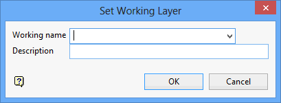
Working name
Enter, or select from the drop-down list, the name of the working layer. The chosen layer will be set as the active working for underground coal operations. It does not affect the layer set through the Layer option (under the Design > Create submenu)
To create a new layer, enter the layer name. The layer name...
- may contain up to 40 characters.
- must begin with an alphanumeric character [0 - 9] or [a - z].
- cannot include spaces.
- can include hyphens [ - ], plus signs [ + ], underscores [ _ ], periods/dots [. ].
- can include the special characters of ÁÂÃÀÇÉÊÍÓÔÕÚÜÑ that are used in the Spanish and Portuguese languages.
Description
Enter a description to further describe the contents of this layer. The description can be up to 80 alphanumeric characters and may include spaces. If a description is not entered, then a default description will be used instead. If the chosen layer already has an assigned description, the description will be displayed when the layer is selected. Existing layer descriptions can be overwritten.
To add to an existing working layer, the layer must be loaded onto the screen. If a working layer by the same name already exists in the currently open database, but has not been loaded, then you will be asked whether you want to select the layer or replace it.
Click OK.
Select OK.
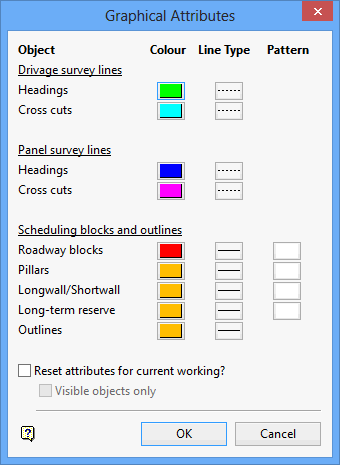
Drivage survey lines
A colour and line type can be set for roadways created as drivages. The colour is selected from the current colour table; the line type from a list of line types that is delivered with the system.
Panel survey lines
A colour and line type can be set for roadways created as panels. As above, a colour is selected from the current colour table; a line type from a list supplied with the system.
Scheduling blocks and outlines
A colour, line type and pattern can be set for scheduling blocks (roadway, pillars, longwall/shortwall, long term reserves). The same can be set for outlines. Outlines are used for plotting purposes. As above, a colour is selected from the current colour table; a line type from a list supplied with the system.
Reset attributes for current working
Select this check box if you want the changes to affect the current working layout.
Visible objects only
Select this check box if you want the changes to only affect the visible objects. This option is only applicable when resetting attributes.
Click OK.
The setting are then stored in the ENVIS_RESO area and will be used whenever a new session is started. If you chose to reset the attributes, then the current working will be changed immediately.

