Area
Use the Area option to get the area of your panel, roadway blocks, pillars, and extraction ratio.
Instructions
On the Underground menu, point to Coal Development, and then click Area to display the Projection-block deletion panel.
(If a working layer was not defined prior to selecting this option, then the Set Working Layer panel is displayed first.)
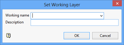
Working name
Enter, or select from the drop-down list, the name of the working layer. The chosen layer will be set as the active working for underground coal operations. It does not affect the layer set through the Layer option (under the Design > Create submenu)
To create a new layer, enter the layer name. The layer name...
- may contain up to 40 characters.
- must begin with an alphanumeric character [0 - 9] or [a - z].
- cannot include spaces.
- can include hyphens [ - ], plus signs [ + ], underscores [ _ ], periods/dots [. ].
- can include the special characters of ÁÂÃÀÇÉÊÍÓÔÕÚÜÑ that are used in the Spanish and Portuguese languages.
Description
Enter a description to further describe the contents of this layer. The description can be up to 80 alphanumeric characters and may include spaces. If a description is not entered, then a default description will be used instead. If the chosen layer already has an assigned description, the description will be displayed when the layer is selected. Existing layer descriptions can be overwritten.
To add to an existing working layer, the layer must be loaded onto the screen. If a working layer by the same name already exists in the currently open database, but has not been loaded, then you will be asked whether you want to select the layer or replace it.
Click OK.
Set Working Layer panel
Working name
Enter, or select from the drop-down list, the name of the working layer. The chosen layer will be set as the active working for underground coal operations. It does not affect the layer set through the Layer option (under the Design > Create submenu).
To create a new layer, enter the layer name. The layer name:
- may contain up to 40 characters.
- must begin with an alphanumeric character [0-9] or [a-z].
- cannot include spaces.
- can include hyphens [ - ], plus signs [ + ], underscores [ _ ], periods/dots [. ].
- can include the special characters of ÁÂÃÀÇÉÊÍÓÔÕÚÜÑ that are used in the Spanish and Portuguese languages.
Description
Enter a description to further describe the contents of this layer. The description can be up to 80 alphanumeric characters and may include spaces. If a description is not entered, then a default description will be used instead. If the chosen layer already has an assigned description, the description will be displayed when the layer is selected. Existing layer descriptions can be overwritten.
To add to an existing working layer, the layer must be loaded onto the screen. If a working layer by the same name already exists in the currently open database, but has not been loaded, then you will be asked whether you want to select the layer or replace it.
Select OK.
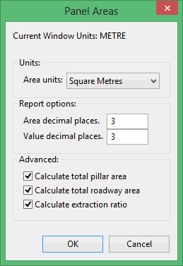
Units
Select the units in which you would like the area to be reported.
Report options
Type in the number of decimal places to report the area and extraction ratio value to.
Advanced
Select the additional area option to report on. If no option is selected here, the report window will only display the areas of the individual roadway polygons and not the totals. Pillar area is equal to the panel area minus the area of the roadway block polygons. Roadway area is the total of the roadway polygon areas. Extraction ratio is roadway area divided by the total panel area. The panel area is the roadway area plus the pillar area.
Note: This option is best used on a panel or group where the roadway and pillar polygons have been created. Running this option on heading and crosscuts will result in undefined areas an extraction ratios.
Click OK.
Select the panel group to be evaluated. Clicking on any object, heading, crosscut, roadway polygon, or pillar polygon, within the group will result in an area report.

