Filters
Source file: filter-2.htm
Click on a menu option on the image below to display more information.
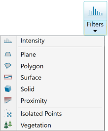
Filter options are:
-
Intensity: Filters scan points based on intensity values (useful for filtering dust clouds (typically low intensity) or to filter high intensity points for locating survey reflectors). More
-
Plane: Define 3D planes and remove points on one side of the plane. More
-
Polygon: Filters scan data specified by a polygon and retains points inside or outside the polygon. More
-
Surface: Use to define 3D surfaces and remove points on one side of the surface. More
-
Solid: Use to filter data inside or outside a 3D shape. More
-
Proximity: Filters points by their distance to an object. Keep or remove points within a specified distance of the base object. More
-
Isolated points: Filters points that are a large distance from any other points (useful for filtering dust particles or insects that have been scanned). More
-
Vegetation Filter: Efficient filter for adjusting the removal of points above the ground plane. Based on Topography filter. More
