Introduction
Starting FieldHHC
-
To start FieldHHC, press the power button on the FieldHHC tablet.
Note: When connecting to a scanner for the first time, a warning about scanning survey prisms is displayed. Tap OK to dismiss the warning. Tap Do not show this warning to prevent the warning from appearing for 30 days.
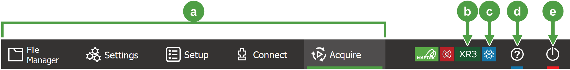
Main tabs
FieldHHC consists of a series of tabs for managing different aspects of the scanning workflow.
|
|
|
Figure 7-2 Main tabs on the FieldHHC user interface |
|
|
Main tabs:
|
|
|
|
|
|
Cold climate scanner (M20) indicator. |
|
|
Open this operator manual. |
|
|
Power button. Choose from the following options:
|

 File Manager
 Settings
 Setup
Setup Connect
 Acquire


Status bar
The status bar displays messages and various status indicators.
|
|
|
Figure 7-3 Example status bar (appearance varies based on current status) |

|
|
Notification banner |
The most recent notifications and error messages appear here. Tap on the banner to display the full list of notifications. |
||||||||||||
|
|
|
|||||||||||||
|
|
|
|||||||||||||

|
|
|||||||||||||
|
|
Internal GPS status |
|
||||||||||||
|
|
|
|||||||||||||
|
|
Data transfer status |
|
||||||||||||
|
|
|
|||||||||||||
|
|
|
|||||||||||||
|
|
FieldHHC tablet battery charge indicator |
|
||||||||||||
|
|
Clock |
|


Basic scanning workflow
You can perform a basic scan job in FieldHHC by following this workflow:
-
Turn on the FieldHHC tablet.
-
Import required files.
If you want to set a coordinate system or use a survey station database, you will first need to import them into FieldHHC. To do this, follow these steps:
-
Insert a USB device containing the required files into the FieldHHC tablet.
-
In the File Manager tab, expand the Files drawer.
-
Tap
 to show files on the USB device.
 -
Select the required files, then tap
 to transfer them to the FieldHHC.
See Managing non-scan file types for detailed instructions.
-
-
Configure FieldHHC.
Switch to the Settings tab and configure any system settings required, such as:
-
Operator name
-
Coordinate system
-
Bluetooth GPS connection
See Configuring FieldHHC for detailed instructions.
-
-
Connect to the scanner.
-
Turn the scanner on.
-
If using a wired connection, connect the scanner to the FieldHHC tablet by plugging the supplied Ethernet cable into the Ethernet port of each device.
-
When the Connect tab becomes enabled, tap it to connect to the scanner.
See Connecting to a scanner for detailed instructions.
-
-
Set up the job.
-
Switch to the Setup tab.
-
Select the kind of scan job you want to perform, either Defined Name, Survey Job, or Multiple Back sights.
-
Configure the setup as required, for example, by setting a scan name or survey job.
See Setting up a scan job for detailed instructions.
-
-
Acquire a scan.
-
Switch to the Acquire tab.
-
Choose the desired settings such as Photo Capture, Level, Scan Mode, and Point Density.
-
To take a preview, tap
 .
. -
Optionally select a region to scan by tapping
 then drawing the desired region in the preview window.
 -
To acquire the scan, tap
 .
.
See Acquiring scans for detailed instructions.
-
-
View the scan.
Switch to the File Manager tab to view the scan and perform other functions such as annotating scans and transferring scans to a USB key.
See Viewing scans for more information.
-
Take more scans.
You can take more scans by switching back to the Acquire tab. When you move to a new setup location, switch to the Setup tab to configure the details of the new setup location before acquiring the next scan.
See also: Scanning with Maptek Drive
