Reliability
If required, define a level above which data is not considered reliable. Typically, this is due to the effects of weathering.
For example, if a roof intercept is logged above the uncertainty surface, then the location of this roof is treated as unreliable and may be lifted above its currently logged position should surrounding data warrant the roof interpolation. The location is never interpolated lower than the logged roof location.
If both the roof and floor are above the uncertainty surface, both may be moved based on surrounding data, but the thickness of the horizon is not interpolated thinner than its logged thickness.
Check Use base of weathering/uncertainty information to activate options.
Options function individually or concurrently.
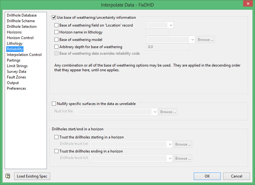
Use of base of weathering/uncertainty information
Select this check box to enable the options.
Base of weathering field on 'Location' record
This s used when there is a dedicated field on the Location (or Header) record of each hole which contains the depth to the weathering level. Select the field which defines the depth of weathering values.
Horizon name in lithology
This is a commonly used method of storing base of weathering information in a drillhole database. The depth of weathering position is signified by a field code in the Horizon field defined on the Drillhole Scheme pane. In this example, the field code is DOW.
Base of weathering model
This uses an existing surface grid model to define the level of the weathering. This is the most flexible method of defining weathering as the grid may be constructed from several sources such as logged intervals, survey pickups, or logical statements based on depth below topography. In this example, defdow.sfg is the depth of weathering surface.
Arbitrary depth for base of weathering
This is a simplistic method which uses a single depth down the hole for every hole as the base of weathering location. In the example, the arbitrary depth is 12 units.
Note: If more than one definition is selected, they are applied in top down order (as they appear on the panel, not in the drillhole) until a match is found. The first, matching, true definition is used. The procedure is applied to each hole independently.
If no definition applies to a drillhole, then no depth of weathering will be considered for the interpolation in that hole.
See Diagrams below to view the use of this control and the effect is has on the resultant grids.
Base of weathering data overrides reliability code
If Use reliability field for intercept depth and thickness was checked in the Drillhole Scheme subpanel, the Base of weathering data overrides reliability code option in enabled in the Base of Weathering/Uncertainty subpanel.
If Base of weathering data overrides reliability code is not checked in the Base of Weathering/Uncertainty subpanel, the reliability code selected in the Drillhole Scheme subpanel will take precedence over the DOW data reliability position.
Nullify Surfaces
This option allows a pre-defined Null list file to be used to exclude the roof or floor of individual horizons from the logged data. The file is of a simple format such as:
ABC0003, C1, roof
Where ABC003 is the name of the drillhole in question, C1 is the seam to be nullified and, in this case, the position of the roof interval of the horizon is to be ignored.
It is also possible to have the thickness of the seam be interpolated thinner than that logged.
The file name used to define a nullify list is of the format <file name>.nul.
Available operators are shown below.
It is not possible to nullify both the roof and the floor of the same horizon in the same hole. Use a reliability flag to achieve this goal. See "Optional Lithology Fields".
Available Operators
| Operator | Description |
| ROOF | Roof interval igored, interval may be logged thicker or thinner. |
| FLOOR | Floor interval ignored, interval may be logged thicker or thinner. |
| NODATA | The default if not 4th token given. |
| MAX | Value given is maximum it can be (so, if applied to a roof it means that the value cannot be interpolated lower down the hole, but may be interpolated higher). |
| MIN | Value given is the minimum it can be (so, if applied to a floor it means that the value cannot be interpolated further up the hole, but may be interpolated lower). |
| BAD | Sets the confidence in the value as bad. The location is definitely there, but provides maximum latitude for re-interpolation. |
| AVE | Sets the confidence int eh value as average. The location is definitely there and less latitude for re-interpolation is allowed. In reality, this reliability is probably indistinguishable from BAD. |
| GOOD | Sets the confidence in the value as good. The value from database will not be changed. The value can override other reliability codes read from database. |
Trust the drillholes starting in a horizon
Select this option to specify via a Vulcan selection file the drillholes for which you wish to 'trust' the first logged interval if it happens to fall within a horizon (default value is to treat this as an unreliable intercept and interpolate the roof position from surrounding data)
Trust the drillholes ending in a horizon
Select this option to specify via a Vulcan selection file the drillholes for which you wish to 'trust' the last logged interval if it happens to fall within a horizon (default value is to treat this as an unreliable intercept an interpolate the floor position from surrounding data).
Diagrams:
Without Base or Weathering/Uncertainty used
The following diagram is thinned to match logged interval:
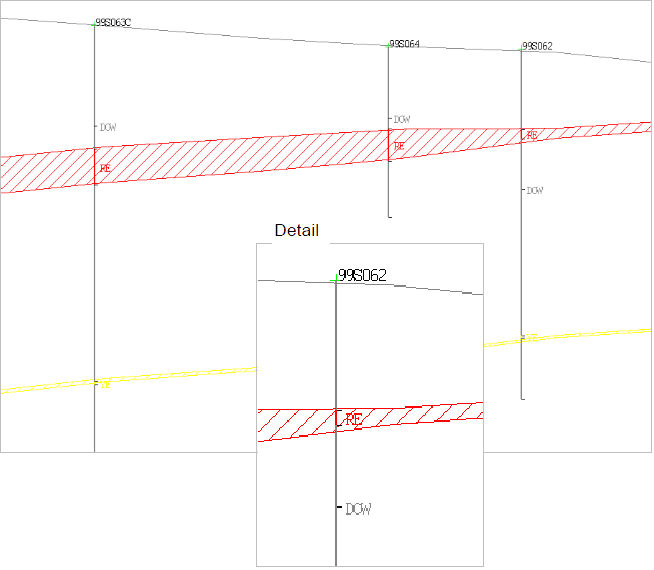
As the DOW position does not affect the reliability of logged data, the RE interval in hole 99S062 is thinned to match the logged interval.
With Base or Weathering/Uncertainty used
The following diagram RE horizon maintains full thickness:
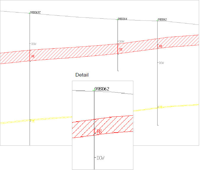
When DOW is used, the RE horizon in hole 99S062 is interpolated to a full thickness as defined by the surrounding intercepts. This is because the logged roof and floor positions of RE in hole 99S062 both fall above DOW. This horizon can be subsequently cropped back to a weathering surface, such as topography, if required.
Related topics
- Overview
- Drillhole Database
- Drillhole Scheme
- Drillhole Selection
- Horizons
- Horizon Control
- Lithology
- Reliability
- Interpolation Control
- Partings
- Limit Strings
- Survey Data
- Fault Zones
- Output
- Preferences

