Preferences
By default, feedback is generated and displayed in the FixDHD tab of the Report Window, as well as output to a log file for auditing purposes.
Take the time to review the feedback output as it highlights data errors and suggests recommended actions.
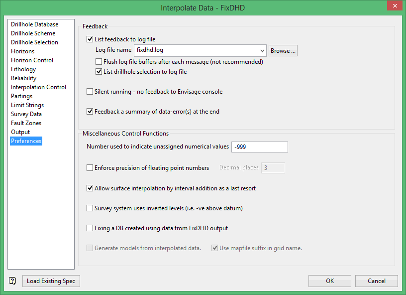
Feedback
List feedback to log file
Select this check box to output the feedback to a nominated log file (.log). Enter a Log file name to store the file in the current working directory. Click Browse to choose another storage location. Alternately, a path can be manually entered along with the file name.
Flush log file buffers after each message
Select this check box to flush the log file buffers after each message. Flushing the log file buffers slows down the fixing process; however, it ensures that messages written to the log file are not lost in the event of a system failure.
List drillhole selection to log file
Select this check box to output drillhole selection list(s) to the nominated log file.
Silent running - no feedback to Vulcan console
Select this check box if you do not want to output the feedback to the Vulcan console. Enabling this option improves the speed at which the fixing process is performed.
We recommend that you only enable this preference when you are familiar with your data set.
Feedback a summary of data-error(s) at the end
Select this check box to summarise all reported data errors. The errors are displayed at the end of the generated log file. If this box is not checked, then the data errors are only reported as they are encountered during the fixing process.
Miscellaneous Control Functions
Number used to indicate unassigned numerical values
Enter the number to represent unassigned numerical data values in the database. This value, if found in the roof or floor of a logged horizon, causes that position to be interpolated.
Enforce precision of floating point numbers
Select this check box to enforce numerical precision on floating numbers extracted from the database. Enter a desired number of Decimal places which should be included in extracted values.
Allow surface interpolation by internal addition as a last resort
When attempting to fix the data, the system searches for all available thickness intervals using the most statistically-significant values to obtain a weighted average. In some cases, a thickness set may not be directly available to fix the missing value.
Check this option to allow a less accurate estimate through the process of adding the weighted average values of the available data for all intercepts between a known value in the drillhole and the missing surface.
If this box is not checked, then a hole is rejected when a surface cannot be fixed. If a result is not obtained, then isolated horizons in the horizon table must be ignored for the data set because a horizon(s) has been identified in holes with no reference to other horizons at the site. This may be due to incorrect correlations, or the holes may need to be drilled deeper to establish a reference connection.
Survey system uses inverted levels
Levels in standard survey systems increase as the data ascends, and this is what FixDHD expects. Check this option to use inverted levels, which decrease as the data ascends.
Fixing a DB created using data from FixDHD output
Select this check box to create a pseudo drillhole database with the output from the fixing process. Extra horizons may be added to this database. Likewise, the output from the fixing process may be added to an existing database.
If this data will be run through another FixDHD pass, then it is a good idea to enable this preference. This allows horizons to be interpolated to full thickness when they are missing between existing seams.
Generate models from interpolated data
Select this check box to generate models directly from the interpolated data using Grid Calc. The modelling parameters must be defined through Geology > Drilling Utilities > Modelling Parameters.
Only the roof and floor of each horizon will be created as this option is intended to allow for a rapid, visual check of the fixing process. Use Geology > Drilling Section options to check the resulting grids.
Grids generated from this option should not be used for resource estimation and mine design.
Use mapfile suffix in grid name
Select this check box to allow grids to be generated without the optional suffix used on mapfiles.
Related topics
- Overview
- Drillhole Database
- Drillhole Scheme
- Drillhole Selection
- Horizons
- Horizon Control
- Lithology
- Reliability
- Interpolation Control
- Partings
- Limit Strings
- Survey Data
- Fault Zones
- Output
- Preferences

