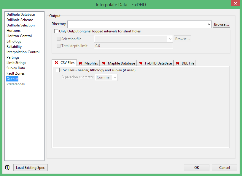
Output
Only Output original logged intervals for short holes
Use this option to specify via a Vulcan selection file and/or a specified total depth value, a series of drillholes for which only logged intervals and intervals estimated from the immediate splitting relationship are included in the FixDHD output. This is predominantly required when subsequent surface modelling shows 'artefacts' being introduced due to a lack of logged horizon sequence in the selected holes.
The Output section configures output files for fixed data. Multiple outputs may be checked. At least one format must be chosen.
The Output panel has the following five tabs:
- CSV Files
- Mapfiles
- Mapfile Database
- FixDHD Database
- DBL File
CSV Files
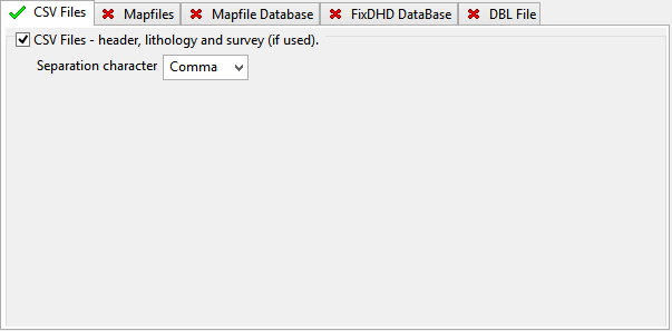
CSV Files - header, lithology and survey (if used).
Select this check box to output data to CSV files (.csv). By default, two files are produced: one containing header records and another containing lithology records.
If downhole survey information is included in the data, then an additional file is produced. The depth values for drillholes which contain downhole survey records are reported with associated dip and azimuth values. This output can be directly loaded into a database.
The resulting files are named using the following naming convention:
<database name>_header.csv
<database name>_litho.csv
<database name>_dsr.csv
where <database name> refers to the name of the database used.
Select the separation character used between values in the resulting CSV files. A Comma (,) is the default selection.
Mapfiles

Check Mapfiles – for each child horizon in table to output the information to mapfiles (.map). A map file is produced for the lowest level child horizon defined in the horizon table.
The format of the resulting map files is similar to FIXMAP map files. FixDHD mapfiles contain less whitespace and possess additional fields shown in the tables below:
Supplemental fields in FixDHD mapfiles:
| FIX_TK | The interpolated seam thickness at a drillhole position when not given in the ST/TK columns because the seam it is known to be missing in the hole from the database log. |
| R_STATUS | The status of the data given for the roof values. |
| F_STATUS | The status of the data given for the floor values. |
| T_STATUS | The status of the data given for the thickness value. |
| P_STATUS | The status of the data given for the parting value. |
Information about how data is derived:
| DB | Data derived directly from the logged data within the database without modification. These values had good reliability, therefore they were used directly. |
| DB_FIXED | Data derived from logged data that required some amount of fixing by this process. Examples of this occurs include:
|
| FIXED | Data derived entirely by interpolation within this process. |
| MODEL | Data derived from an external reference control model. |
| UNKNOWN | Data item of unknown provenance. This should never be seen as it usually indicated that an error has occurred in the process. |
The resulting files are named using the following naming convention:
<proj><horizon><suffix>.map
where <proj> refers to the project code, <horizon> refers to the horizon name and <suffix> refers to the characters used to distinguish the resulting files from normal map files. The default value for the suffix is '_Z', but any value, up to three characters in length, can be entered.
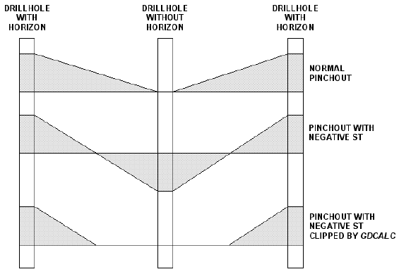
To ensure the best representation of the data, known missing horizons are given zero thickness. When modelling directly from these mapfiles, a horizon will pinch to zero thickness at the first drillhole where an area of zero thickness is encountered.
Check Substitute interpolated horizon thickness for ST of known zero thickness horizons to substitute the interpolated thickness value for the structure thickness of a known zero thickness horizon. When modelling from mapfiles with interpolated thicknesses, unknown horizons will not pinch to zero thickness. When a mask is applied to a model, horizons stop squarely at the mask boundary with no change in thickness.
The following substitution methods are available:
- Substitute interpolated thickness
- Substitutes the interpolated thickness value for the structure thickness of a known zero-thickness horizon.
- Substitute negative interpolated thickness
Substitutes a negative interpolated thickness value for the structure thickness of a known zero thickness horizon. The effect in the final model is that horizons thin between the holes that have or do not have the horizon rather than at the hole that does not have the horizon. To make a sensible looking final model the roof must be clipped to the floor in Grid Calc.
The negative value can be modified with an entered Multiplier value. The default multiplier, 1.0, causes the pinch out halfway between drillholes. Increase the multiplier to move the pinch out closer to the drillholes with the horizon. Decrease the multiplier to move the pinch out closer to the drillhole without the horizon.
The following figure illustrates the effect of mapfile multiplier value on horizon pinchouts:
Mapfile Database
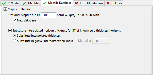
Check Mapfile Database to output the information to a Mapfile Database (.fxd), which results in an Isis equivalent of ASCII mapfiles. Mapfile Databases provide:
- greater security,
- improved file management, and
- access to the validation and manipulation capabilities of Isis
The resulting files are named using the following naming convention:
<proj><run ID>.fxd.isis
An Isis mapfile database or Mapbase should not be confused with an interpolated drilling database. The structure of the data in a Mapbase is identical to that in the mapfiles, and cannot be viewed as a drillhole on screen.
FixDHD Database
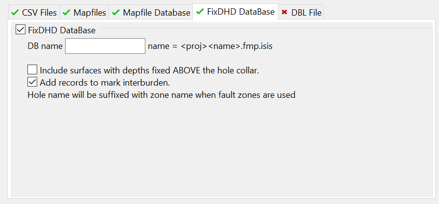
This creates a pseudo drillhole database from the output run of the interpolation. The information contained is identical to that output created by the CSV file output. This database may be compared to the input drillhole database, correlated or modelled from directly. This also opens the possibility of editing the interpolations prior to modelling
- Check Include records with depths fixed ABOVE the hole collar to artificially adjust the collar elevation of any holes where horizons are interpolated to be above the input collar location. This eliminates the need for negative TO and FROM depths.
- Check Add records to mark interburden to explicitly include interburden TO and FROM depths, rather than just outputting the horizons.
The resulting files are named using the following naming convention:
<proj><run ID>.fmp.isis
where <proj> is the project code and <run ID> is the value entered into the Output subpanel.
DBL File
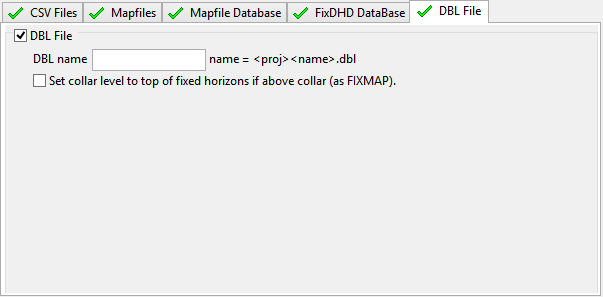
Check DBL File to output the information to a Database Listing file (.dbl). The format of the resulting file is similar to the one used by FIXMAP.
By default, collar levels remain unchanged, so horizons interpolated above the collar will have negative depths. Check Set collar level to top of fixed horizons if above collar to adjust the collar level to the top of the upper seams in these holes.
Related topics
- Overview
- Drillhole Database
- Drillhole Scheme
- Drillhole Selection
- Horizons
- Horizon Control
- Lithology
- Reliability
- Interpolation Control
- Partings
- Limit Strings
- Survey Data
- Fault Zones
- Output
- Preferences

